
Images


August 27, 2015 - Typhoon Atsani (17W) in the Pacific Ocean
 Tweet
Tweet
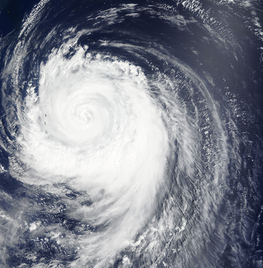
NASA's Aqua satellite saw a clear and large eye in Typhoon Atsani as it passed over the storm on August 21, 2015. At 0315 UTC (August 20 at 11:15 p.m. EDT) the Moderate Resolution Imaging Spectroradiometer (MODIS) aboard that satellite captured this true-color image of the storm.
The image shows a large storm with a 53 mile- (85 km-) wide eye and a tight apostrophe shape. At 1500 UTC (11 a.m. EDT) that same day Atsani's maximum sustained winds were near 115 mph (185 km/h). It was centered near 25.9 North latitude and 145.3 East longitude, about 397 miles (638.9 km) east-northeast of Iwo To. Atsani was moving to the northwest at 10.3 mph (16.6 km/h) and was beginning to turn towards to the northeast.
The storm was first seen in the Northwest Pacific Ocean as Tropical Depression 17W on August 14 and formed roughly 265 miles north of Enewetak and about 370 miles southwest of Wake Island. Due to favorable conditions, the storm strengthened rapidly and reached Super typhoon status on August 19. According to the Global Disaster Alert and Coordination System (GDACS) Typhoon Atsani’s maximum sustained winds reached 161 mph (259 km/h), or a Category 5 storm on the Saffir Simpson Hurricane wind scale on that date.
By late on August 20, unfavorable conditions were having an effect on the storm, and Atsani began to slowly weaken. Early on August 26 the last advisory on the system was issued by the Joint Typhoon Warning Center as it was transitioning into an extra-tropical cyclone. At that time maximum sustained winds were about 69 mph (111 km/h) and the storm was located about 1,226 mi (1,972 km) south of Petropavlovsk, Russia. The rain-filled remnants triggered watches and warnings for heavy rain and snow in portions of Alaska. A winter storm watch is effect north of Fairbanks, Alaska through the evening of August 27.
Image Facts
Satellite:
Terra
Date Acquired: 8/22/2015
Resolutions:
1km (1006.2 KB), 500m (3.3 MB), 250m (7.8 MB)
Bands Used: 1,4,3
Image Credit:
Jeff Schmaltz, MODIS Land Rapid Response Team, NASA GSFC
