
Images


October 14, 2015 - Fall colors in the northeastern United States
 Tweet
Tweet
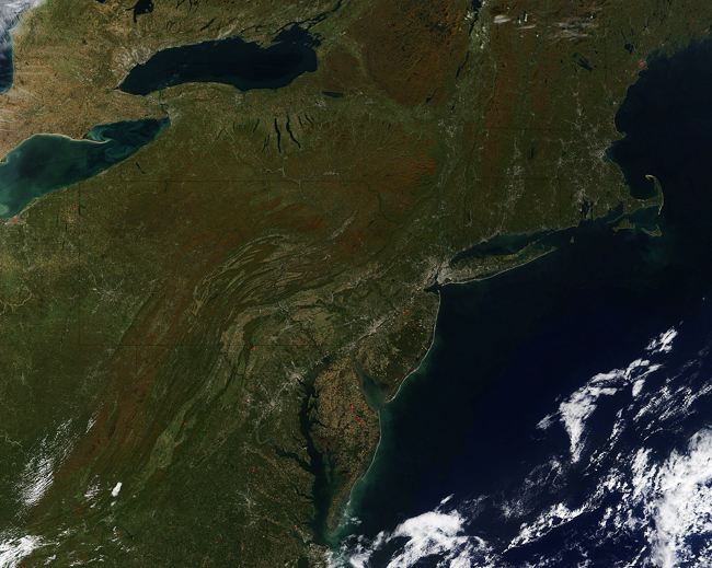
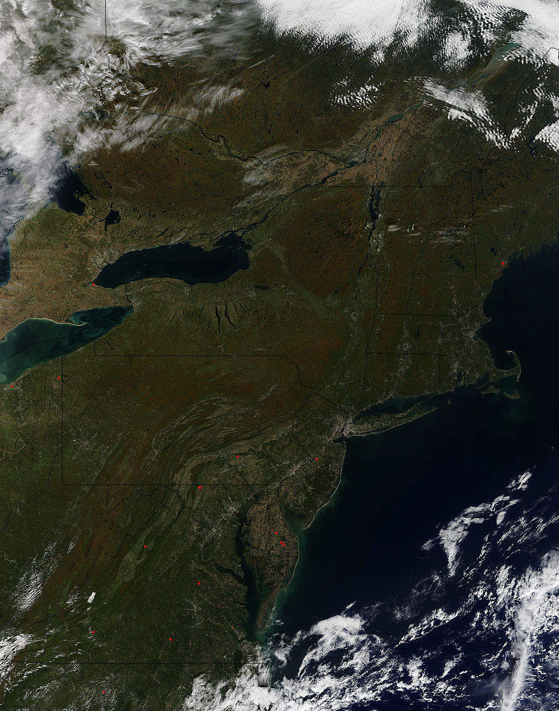
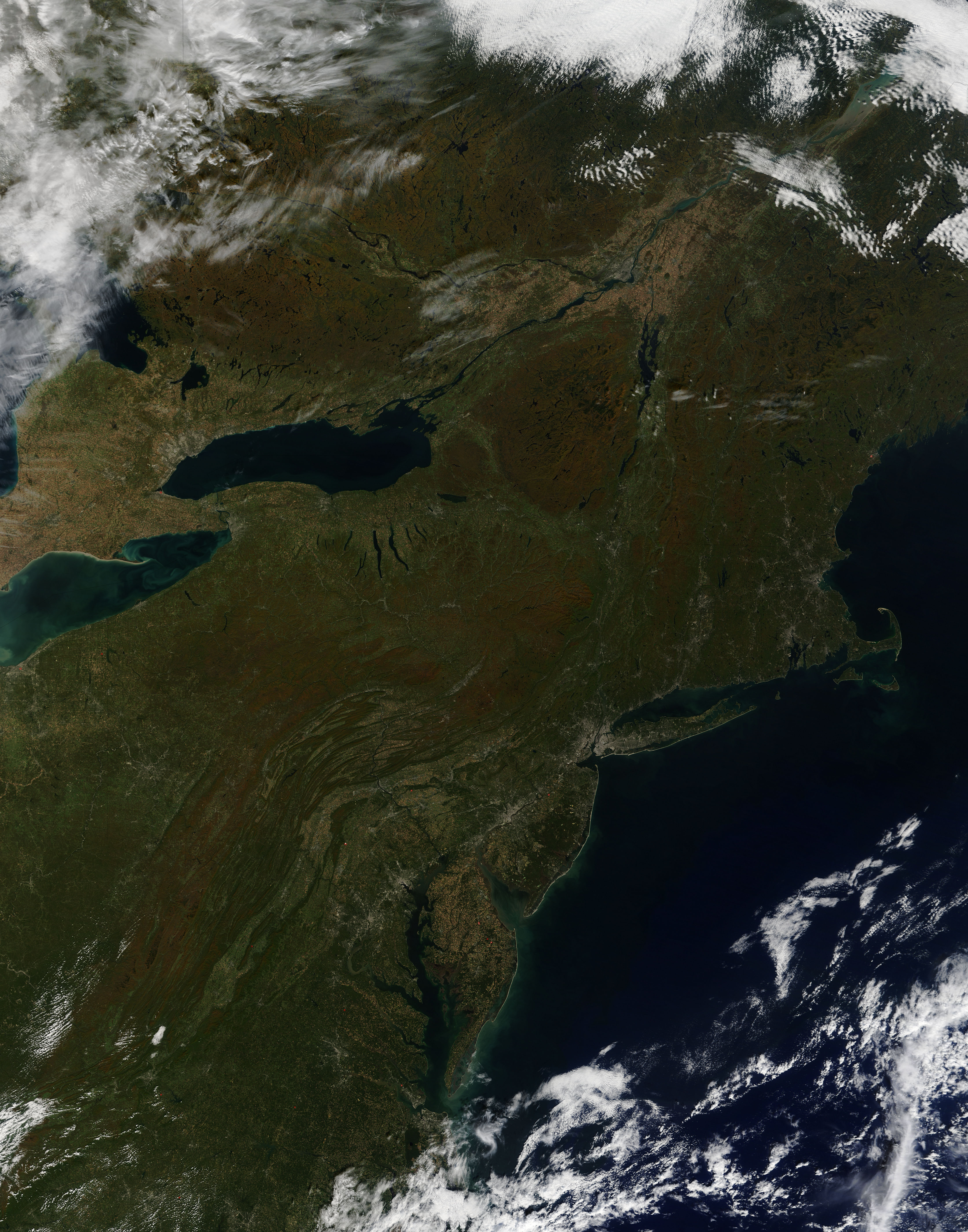
Fall foliage was nearing peak color across much of the northeastern United States on October 12, 2015. The Moderate Resolution Imaging Spectroradiometer (MODIS) aboard NASA�s Terra satellite captured this stunningly clear true-color image at 1605 UTC (12:05 pm EDT) on that same day. Fall foliage was nearing peak color across much of the northeastern United States on October 12, 2015. The Moderate Resolution Imaging Spectroradiometer (MODIS) aboard NASA�s Terra satellite captured this stunningly clear true-color image at 1605 UTC (12:05 pm EDT) on that same day.
Throughout the deciduous forests, the landscape reflects the yellows, oranges and reds of autumn leaf color mixed with greens of unchanged deciduous trees and also the greens of evergreen trees, such as pine and spruce. The coloration is strong in the rugged Appalachian Mountains which run from Georgia (south of this image) through Maine. Upstate New York and the mountains of New Hampshire and Vermont are also strikingly colored, as are the forests in the provinces of Ontario and Quebec, Canada. In the far north, nearly underlying the bright white clouds, the boreal forests remain predominantly deep green, reflecting the high percentage of evergreen trees in such forests.
While the tree leaf color is the most striking change seen from space in autumn, color changes occur in grasslands and agricultural regions as well. Such areas generally turn tan in the fall as the grasses and crops become dried and begin to die or are harvested. This agricultural tan can be seen in the Delmarva Peninsula (the peninsula where Delaware, Maryland and Virginia meet), as well as southern Canada and the St. Lawrence River valley, especially close to Quebec City. The city itself, like other cities, is seen as an area of grey pixels on the St. Lawrence River. Additional signs of human habitation are the grey pixels along the Interstate 95 corridor near the eastern seaboard. This highway joins many major cities, the most notable of which is New York City, which can be seen as a very large area of grey near New Jersey and encompassing much of Long Island.
Throughout the deciduous forests, the landscape reflects the yellows, oranges and reds of autumn leaf color mixed with greens of unchanged deciduous trees and also the greens of evergreen trees, such as pine and spruce. The coloration is strong in the rugged Appalachian Mountains which run from Georgia (south of this image) through Maine. Upstate New York and the mountains of New Hampshire and Vermont are also strikingly colored, as are the forests in the provinces of Ontario and Quebec, Canada. In the far north, nearly underlying the bright white clouds, the boreal forests remain predominantly deep green, reflecting the high percentage of evergreen trees in such forests.
While the tree leaf color is the most striking change seen from space in autumn, color changes occur in grasslands and agricultural regions as well. Such areas generally turn tan in the fall as the grasses and crops become dried and begin to die or are harvested. This agricultural tan can be seen in the Delmarva Peninsula (the peninsula where Delaware, Maryland and Virginia meet), as well as southern Canada and the St. Lawrence River valley, especially close to Quebec City. The city itself, like other cities, is seen as an area of grey pixels on the St. Lawrence River. Additional signs of human habitation are the gray pixels along the Interstate 95 corridor near the eastern seaboard. This highway joins many major cities, the most notable of which is New York City, which can be seen as a very large area of gray near New Jersey and encompassing much of Long Island.
Image Facts
Satellite:
Terra
Date Acquired: 10/12/2015
Resolutions:
1km (467.5 KB), 500m (1.8 MB), 250m (4.6 MB)
Bands Used: 1,4,3
Image Credit:
Jeff Schmaltz, MODIS Land Rapid Response Team, NASA GSFC
