
Images


January 31, 2016 - Sediment and cloud streets in the Gulf of Mexico
 Tweet
Tweet
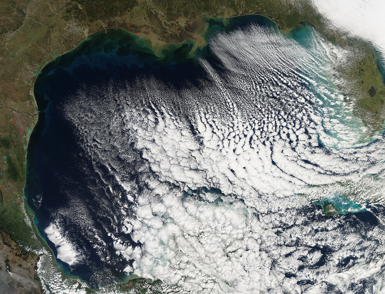
In late January 2016, a massive winter storm struck the eastern United States, spreading frigid air and high winds from Florida to New England and ultimately dumping historic high snowfalls in parts of the Mid-Atlantic region.
On January 22 a low pressure center associated with the storm front hung over the southeastern United States. By January 23 the center had moved northeastward over the Delmarva Peninsula (Delaware/Maryland/Virginia). While the snow fell with a vengeance in the Mid-Atlantic from January 23-24, strong winds and cold temperatures were being felt further south. On January 23, Mobile, Alabama registered low temperatures of 33˚F (0.6˚C) with northwesterly winds at 16 - 22 mph (25.7 - 35.4 km/h) and Pensacola, Florida reported lows of 32˚F (0˚C) and highs of 45˚F (7.2˚C). Average highs and lows on this date for Pensacola are 61˚F (16.1˚C) and 42˚F (5.5 ˚C), respectively.
On January 23, the Moderate Resolution Imaging Spectroradiometer (MODIS) aboard NASA's Aqua satellite flew over the southeastern United States and captured this true-color image of the southeastern United States.
The most striking feature visible is the linear arrangement of the clouds over the Gulf of Mexico. The long rows of parallel clouds are called "cloud streets". These clouds formed when cold, dry air blowing out of the northwest swept over the warm, moist air over the Gulf. The fast-moving cold air chilled the moist air until the water vapor condensed into clouds that followed the winds past. In addition to the clouds, waves of sediment can be seen in the waters along the coastline. The sediment is a muddy tan where it pours into the blue Gulf waters, such as at the Mississippi Delta. As the sediment sinks, the reflectivity changes causing it to appear light green, then darker green as it drops lower in the water.
Image Facts
Satellite:
Aqua
Date Acquired: 1/23/2016
Resolutions:
1km (1.2 MB), 500m (4.2 MB), 250m (10.2 MB)
Bands Used: 1,4,3
Image Credit:
Jeff Schmaltz, MODIS Land Rapid Response Team, NASA GSFC
