
Images


April 22, 2016 - Greece, Turkey, and the Aegean Sea
 Tweet
Tweet
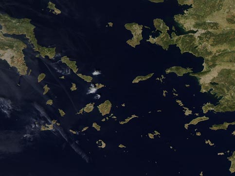
The Aegean Sea is a unique saltwater sea that is bounded by Turkey on the east and by Greece on the north and west. An arc of Greek islands (Rhodes, Crete, and Kythera) define the southern boundary of the Aegean. The Aegean is one of the four major basins of the eastern Mediterranean Sea, and it is unique in that more than 3,000 islands are scattered across the approximately 240,000 sq. km. (92,664 sq. mi) area.
On April 17, 2016, the Moderate Resolution Imaging Spectroradiometer (MODIS) aboard NASA's Aqua satellite passed over the Aegean Sea and captured a true-color image of the region.
Near the edge of the west (left) side of the image, a group of gray pixels can be seen. This large smudge is the city of Athens, home to approximately 655,000 people. Athens is the largest city in Greece as well as the capital of the country. Turkey lies on the east side of the Aegean.
Most of the islands captured in this image belong to the Cyclades group, so named because they encircle the tiny, sacred island of Delos. Delos is thought to have been inhabited as early as the 3rd millennium B.C., and one of its multiple mystic and holy claims was its reputation as the birthplace of the twin gods, Apollo and Artemis.
Image Facts
Satellite:
Aqua
Date Acquired: 4/17/2016
Resolutions:
1km (46.8 KB), 500m (100.5 KB), 250m (204.1 KB)
Bands Used: 1,4,3
Image Credit:
Jeff Schmaltz, MODIS Land Rapid Response Team, NASA GSFC
