
Images


May 19, 2016 - England and France
 Tweet
Tweet
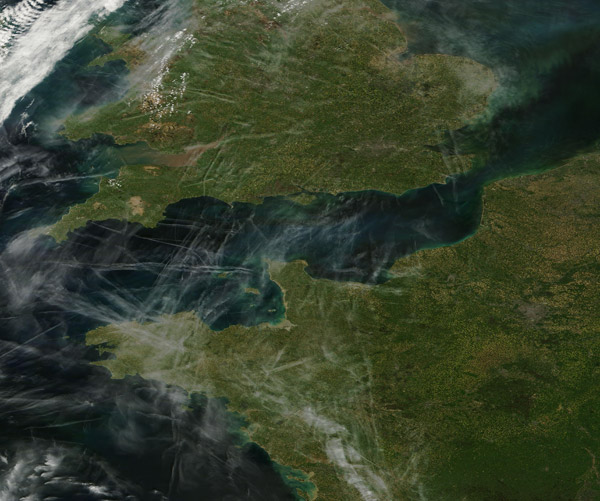
The skies over England and France were cross-hatched by contrails in early May 2016. Condensation trails ("contrails") that form behind high-altitude aircraft are one of the most visible signs of human impact on the atmosphere. The composition of these long, narrow clouds is virtually identical to naturally-forming cirrus clouds. Cirrus clouds are formed when naturally high levels of humidity exist in the atmosphere. Contrails, in contrast, form when airplanes inject extra water vapor into the atmosphere through their exhaust.
The humidity of the air affects how long contrails remain visible. When the air is dry, contrails dissipate within seconds or minutes. But when the air is humid, contrails can be long-lived and spread outward until they become difficult to distinguish from naturally occurring cirrus clouds. Most remain visible for just a few hours.
The Moderate Resolution Imaging Spectroradiometer (MODIS) aboard NASA's Terra satellite captured this true-color image on May 5, 2016. England lies to the north and France to the south and the English Channel separates the two countries.
With major airports in London and Paris, the airspace in this region is extremely busy, as suggested by the number of contrails. London's Heathrow airport is one of the world's busiest airports. In 2012 it ranked as the third busiest behind Hartsfield Jackson Atlanta International and Beijing Capital International. More than 70 million passengers moved through Heathrow in 2012.
Image Facts
Satellite:
Terra
Date Acquired: 5/5/2016
Resolutions:
1km (201.1 KB), 500m (595.5 KB), 250m (2.1 MB)
Bands Used: 1,4,3
Image Credit:
Jeff Schmaltz, MODIS Land Rapid Response Team, NASA GSFC
