
Images


December 13, 2018 - Floods in Iraq
 Tweet
Tweet
While November typically brings wet weather to Iraq, November 2018 brought even more frequent and intense rain storms than usual. On November 22-23, an especially potent storm dropped torrential rains across northern and central Iraq.
According to the United Nations Office for the Coordination of Humanitarian Affairs (OCHA), the resultant flooding affected an estimated 22,000 people in Ninewa and 10,000 people in Salah al-Din. Qayyarah Airstrip, Jeddah, Salamiyah, Hamam Al Alil and Nimrud IDP camps in Ninewa were signinificantly impacted, as was the town of Shirqat in Salah al-Din. Severe flooding in Mosul led to a state of emergency being declared by authorities, and concerns about the long-term viability of the Mosul Dam. Hundreds of homes were reported to have been destroyed, especially in towns north of Baghdad, according to news report.
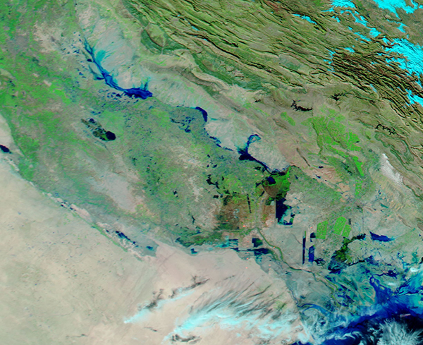
On November 28, 2018, the Moderate Resolution Imaging Spectroradiometer (MODIS) on NASA’s Aqua satellite acquired a false-color image showing water pooling in the floodplains of central and southern Iraq. The false-color image uses a combination of infrared and visible light. Flood water appears dark blue; saturated soil is light blue; vegetation is bright green; and bare ground is brown. This band combination makes it easier to see flood water.
In this image, Baghdad sits near the northwest (upper left) corner on the banks of the Tigris River. The overflowing Tigris crosses the image, flowing to the southeast to empty into the Persian Gulf.
On October 28, 2018, the MODIS instrument on the same satellite acquired an additional false-color image of the same region before the rains and flood. NASA’s Earth Observing System Data and Information System (EOSDIS) created a roll-over comparison between the images collected both before and after the flooding. To explore the comparison, click on this link to EOSDIS
Image Facts
Satellite:
Aqua
Date Acquired: 11/28/2018
Resolutions:
1km (412.5 KB), 500m (885.2 KB), 250m (599 KB)
Bands Used: 1,4,3
Image Credit:
MODIS Land Rapid Response Team, NASA GSFC
While November typically brings wet weather to Iraq, November 2018 brought even more frequent and intense rain storms than usual. On November 22-23, an especially potent storm dropped torrential rains across northern and central Iraq.
According to the United Nations Office for the Coordination of Humanitarian Affairs (OCHA), the resultant flooding affected an estimated 22,000 people in Ninewa and 10,000 people in Salah al-Din. Qayyarah Airstrip, Jeddah, Salamiyah, Hamam Al Alil and Nimrud IDP camps in Ninewa were signinificantly impacted, as was the town of Shirqat in Salah al-Din. Severe flooding in Mosul led to a state of emergency being declared by authorities, and concerns about the long-term viability of the Mosul Dam. Hundreds of homes were reported to have been destroyed, especially in towns north of Baghdad, according to news report.
On November 28, 2018, the Moderate Resolution Imaging Spectroradiometer (MODIS) on NASA’s Aqua satellite acquired a false-color image showing water pooling in the floodplains of central and southern Iraq. The false-color image uses a combination of infrared and visible light. Flood water appears dark blue; saturated soil is light blue; vegetation is bright green; and bare ground is brown. This band combination makes it easier to see flood water.
In this image, Baghdad sits near the northwest (upper left) corner on the banks of the Tigris River. The overflowing Tigris crosses the image, flowing to the southeast to empty into the Persian Gulf. On October 28, 2018, the MODIS instrument on the same satellite acquired an additional false-color image of the same region before the rains and flood. NASA’s Earth Observing System Data and Information System (EOSDIS) created a roll-over comparison between the images collected both before and after the flooding. To explore the comparison, click on this link to EOSDIS
Image Facts
Satellite:
Aqua
Date Acquired: 11/28/2018
Resolutions:
1km (412.5 KB), 500m (885.2 KB), 250m (599 KB)
Bands Used: 1,4,3
Image Credit:
MODIS Land Rapid Response Team, NASA GSFC
