
Images


June 13, 2019 - Utah
 Tweet
Tweet
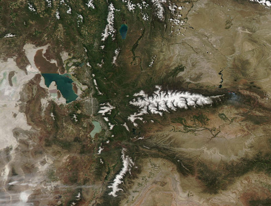
NASA’s Aqua satellite flew over Utah on June 6, 2019, allowing the Moderate Resolution Imaging Spectroradiometer on board to acquire a colorful true-color image of sand, snow, salt and forest.
The primary background tones in this part of Utah are browns and tans—the colors of rock and sand where scant vegetation grows. Dark green marks vegetated areas, primarily forests on the slopes of tall mountains of the Wasatch Range (running roughly north to south near the center of the image) and the Uinta Mountains. White snow blankets the mountain tops, especially of the Uinta. After several winters with below-average snowpack, snows fell abundantly in the winter of 2018-2019. Fresh snow in the Uinta Mountains made road-clearing difficult into the first week of June.
With the abundance of snow, early spring snow melt has helped to bring an extra flush of green to areas that typically remain dry. The snow also has raised water levels in many lakes and streams which were previously at lower than average levels. This includes the Great Salt Lake, a very saline desert lake. According to local reports, the water level of the Great Salt Lake had risen about 2.5 feet (0.76 m) as of June 10—not enough to reverse decades of shrinking size and increasing salinity, but a relief to those who use the lake for recreation or their livelihood.
The broad white area surrounding the Great Salt Lake is the Bonneville Salt Flats. They are remnants of a huge, ancient lake, Lake Bonneville, which existed from 32,000 to 14,000 years ago. Evaporation has left little but white, salt-encrusted flats and the Great Salt Lake. The Bonneville Salt Flats have been used by auto racing enthusiasts for decades. Many land speed records have been set in this location.
Image Facts
Satellite:
Aqua
Date Acquired: 6/9/2019
Resolutions:
1km (110.6 KB), 500m (316.6 KB), 250m (679.1 KB)
Bands Used: 6/9/2019
Image Credit:
MODIS Land Rapid Response Team, NASA GSFC
