
Images


June 14, 2019 - Fires in Democratic Republic of Congo
 Tweet
Tweet
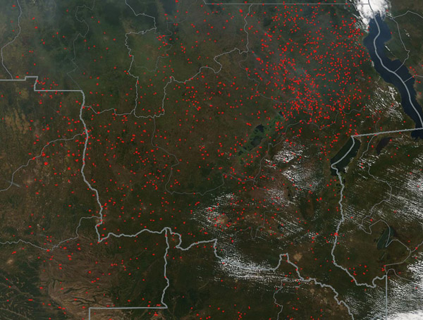
Hundreds of thousands of fires burned across Central Africa in June 2019. On June 10, the Moderate Resolution Imaging Spectroradiometer (MODIS) on board NASA’s Terra satellite acquired a true-color image showing the greens of the Democratic Republic of the Congo speckled with red hot spots. Each hot spot is an area where the thermal bands on the instrument detected high temperatures. When combined with smoke, as in this image, such hot spots are diagnostic for actively burning fire.
Heavy white lines have been overlain on this image to mark the boundaries between countries. Lighter white lines mark provincial borders within the Democratic Republic of the Congo. Most of the area in this image belongs to the Democratic Republic of the Congo, but a portion of Angola and Zambia are also shown. Angola sits in the southwest and Zambia to the southeast.
The Global Forest Watch Fires report for June 5 – 12 recorded 139,277 fire alerts in that week for the Democratic Republic of the Congo. Fires were most dense in the far south of the country in Katanga Province which recorded 67,462 fire alerts in that week. Fires were least dense in the far north and the western edge of that country. Fires also blanketed much of Angola, Zambia, Rwanda, Burundi, and western Tanzania.
The widespread nature of the fires and the time of year strongly suggests that these fires are primarily agricultural in origin. Farmers use fire to clear land for new agricultural use, freshen existing pasture, and burn debris from cropland to prepare for a new planting season. Called “slash and burn”, this type of field clearing is both inexpensive and low tech—and it works. Unfortunately, it also generates smoke which can be hazardous to the health of humans and animals and runs the risk of fires slipping containment to become wildfires, which can consume vast amounts of acreage.
Slash and burn agriculture is widely used in sub-Saharan Africa, and this region accounts for about 70% of burned area worldwide, according to global satellite databases.
Image Facts
Satellite:
Terra
Date Acquired: 6/10/2019
Resolutions:
1km (340.9 KB), 500m (966 KB), 250m (3 MB)
Bands Used: 1,4,3
Image Credit:
MODIS Land Rapid Response Team, NASA GSFC
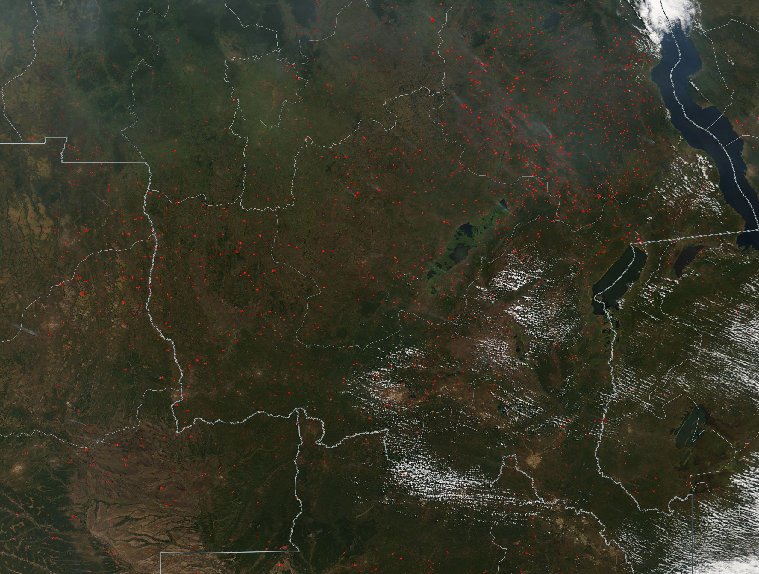
Hundreds of thousands of fires burned across Central Africa in June 2019. On June 10, the Moderate Resolution Imaging Spectroradiometer (MODIS) on board NASA’s Terra satellite acquired a true-color image showing the greens of the Democratic Republic of the Congo speckled with red hot spots. Each hot spot is an area where the thermal bands on the instrument detected high temperatures. When combined with smoke, as in this image, such hot spots are diagnostic for actively burning fire.
Heavy white lines have been overlain on this image to mark the boundaries between countries. Lighter white lines mark provincial borders within the Democratic Republic of the Congo. Most of the area in this image belongs to the Democratic Republic of the Congo, but a portion of Angola and Zambia are also shown. Angola sits in the southwest and Zambia to the southeast. The Global Forest Watch Fires report for June 5 – 12 recorded 139,277 fire alerts in that week for the Democratic Republic of the Congo. Fires were most dense in the far south of the country in Katanga Province which recorded 67,462 fire alerts in that week. Fires were least dense in the far north and the western edge of that country. Fires also blanketed much of Angola, Zambia, Rwanda, Burundi, and western Tanzania.
The widespread nature of the fires and the time of year strongly suggests that these fires are primarily agricultural in origin. Farmers use fire to clear land for new agricultural use, freshen existing pasture, and burn debris from cropland to prepare for a new planting season. Called “slash and burn”, this type of field clearing is both inexpensive and low tech—and it works. Unfortunately, it also generates smoke which can be hazardous to the health of humans and animals and runs the risk of fires slipping containment to become wildfires, which can consume vast amounts of acreage.
Slash and burn agriculture is widely used in sub-Saharan Africa, and this region accounts for about 70% of burned area worldwide, according to global satellite databases.
Image Facts
Satellite:
Terra
Date Acquired: 6/10/2019
Resolutions:
1km (340.9 KB), 500m (966 KB), 250m (3 MB)
Bands Used: 1,4,3
Image Credit:
MODIS Land Rapid Response Team, NASA GSFC
