
Images


September 15, 2019 - Wildfires in Yukon Territory
 Tweet
Tweet
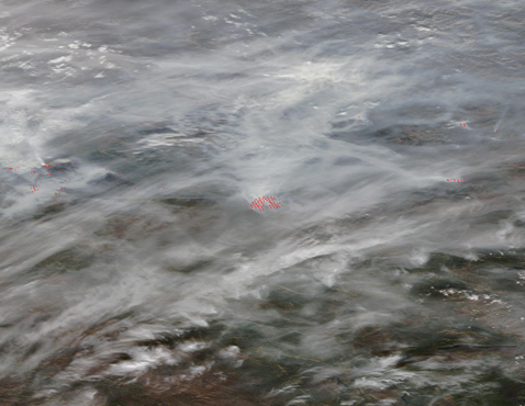
Warm and windy conditions continued to stoke multiple fires burning in Canada’s Yukon Territory, resulting in heavy smoke blanketing the region in mid-September 2019. The Moderate Resolution Imaging Spectroradiometer acquired a true-color image of gray smoke over Yukon Territory on September 11. Mixing with a few white clouds, the smoke creates a blanket so thick that it shrouds the land beneath from view.
Red “hot spots” mark areas where the thermal bands on the instrument detected high temperatures. When combined with typical smoke, as in this image, such hotspots mark actively burning fire. In the center of the image a large fire shows up as a number of hot spots neatly arranged in rows. In fact, that area represents one large fire with very heavy smoke.
As of September 12, the Canadian news company, CBC, reported that there were 52 active wildfires in Yukon. The area with the most activity was the Mayo region of central Yukon, with 20 active fires. The North Crooked Creek fire was particularly aggressive, reaching 17,702 hectares in size on September 11. Wildland Fire Management crews evacuated 18 residents from Ethel Lake ahead of the blaze. An Evacuation Alert was issued by Yukon Emergency Measures Organization for an area with a radius of 5 kilometers (3 miles) around Stewart Crossing and extending 12 kilometers (7.5 miles) south-east to Ethel Lake road.
Image Facts
Satellite:
Terra
Date Acquired: 9/11/2019
Resolutions:
1km (132.5 KB), 500m (329.9 KB), 250m (209.8 KB)
Bands Used: 1,4,3
Image Credit:
MODIS Land Rapid Response Team, NASA GSFC
