
Images


October 16, 2019 - Saddleridge Fire in Los Angeles, California
 Tweet
Tweet
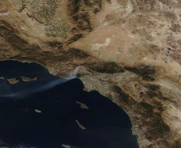
On October 10, 2019, strong Santa Ana winds blew across much of a very dry Southern California, triggering red flag warnings for much of Los Angeles, Ventura, Orange, San Bernardino and Riverside counties. The winds, which gusted as high as 60 mph (96.5 km/h) in some areas, prompted Southern California Edison to shut off power in parts of Los Angeles, Ventura, San Bernardino and Kern counties as a precaution to try to prevent electrical equipment from sparking brush fires.
The precautions proved warranted as several fires broke out in Southern California on October 10-11. The largest, the Saddleridge Fire, ignited in Sylmar near 1-210 at the Yarnell exit. According to a report from the CAL FIRE Information Center, the strong wind fanned the fire, allowing it to jump highway 210 and 5 and “just littering the area with spot fires”. By the afternoon of October 11, the Saddleridge Fire had exploded to 7,500 acres and had destroyed 25 structures. One fatality had been reported that day, as a civilian in the fire area suffered a heart attack.
On October 15, Inciweb Incident Information System reported that the Saddleridge Fire had reached 8,319 acres and had reached 45% containment. It continued to burn in tall grass, brush, and chaparral but exhibited minimal fire activity. It is expected to be fully contained by October 18.
The Moderate Resolution Imaging Spectroradiometer (MODIS) on board NASA’s Terra satellite acquired a true-color image of the Saddleridge Fire on October 11, 2019. Multiple red hot spots mark actively burning fire while smoke pours from the fire, blowing to the southwest and over the Pacific Ocean.
Image Facts
Satellite:
Terra
Date Acquired: 10/11/2019
Resolutions:
1km (167 KB), 500m (435.5 KB), 250m (826.3 KB)
Bands Used: 1,4,3
Image Credit:
MODIS Land Rapid Response Team, NASA GSFC
