
Images


December 5, 2019 - African Fires
 Tweet
Tweet
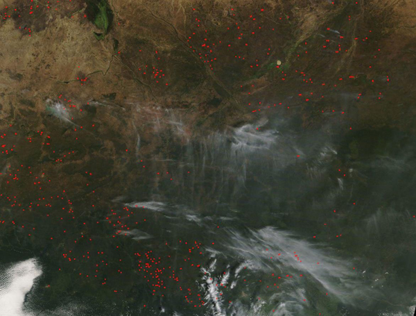
Many dozens of fires were burning across central Africa in the opening days of December 2019.
The Moderate Resolution Imaging Spectroradiometer (MODIS) on board NASA’s Terra satellite acquired a true-color image of fires in Cameroon, Central African Republic, and Chad on December 1. Cameroon sits in the west, Chad in the northeast and the Central African Republic in the southeast. Fires are outlined in red and smoke from those fires appears gray. Some fires appear to be burning on cropland or grass (tan-colored areas) but many fires appear to burn in forested areas. Forests appear dark green.
The location, widespread nature, and number of fires suggest that these fires were deliberately set to manage land. Farmers often use fire to return nutrients to the soil and to clear the ground of unwanted plants especially in places where open land for farming is not readily available because of dense vegetation. Fire is also used to open forested land to new agricultural production. This method of clearing fields, called “slash and burn” is a method of agriculture that has been used by subsistence farmers (farming to survive) for thousands of years. In modern times, the encroachment of slash and burn agriculture on remaining stands of forest has increasingly become an issue central to deforestation, which itself has significant and long-lasting impact on ecosystem destruction and, along with that damage, the loss of species that rely on forest habitat and a significant impact on climate change. Not only does the burning of forest release carbon into the atmosphere, it also reduces the amount of forest that can absorb carbon through tree growth. The combination of decreased absorption along with increased production of atmospheric carbon can lead to climate warming.
The forests burning in this image are a vital part of the Congo Basin forest ecosystem. According to the World Resource Institute, Cameroon’s 22 million hectares of tropical forests provide an important source of revenue, employment, livelihoods, and ecosystem services for people, and also provide habitat for over 9,000 plant species, 910 bird species, and 320 mammalian species. While the country manages the forests for both production and conservation, more than 3,300,000 hectares of Cameroon’s forests have been cleared since 1990—an area the size of Belgium. Increasing pressures from commercial and subsistence agriculture, mining, hydropower and infrastructure puts the welfare of the important forests of Central Africa at risk of destruction.
Image Facts
Satellite:
Terra
Date Acquired: 12/1/2019
Resolutions:
1km (110.9 KB), 500m (387.7 KB), 250m (1.3 MB)
Bands Used: 1,4,3
Image Credit:
MODIS Land Rapid Response Team, NASA GSFC
