
Images


September 17, 2020 - Hurricane Sally and Smoke from West Coast Wildfires
 Tweet
Tweet
The year 2020 will be remembered as a time of extremes, especially in the United States. Not only has the country grappled with a pandemic and political divisions, but also with record-setting fire and hurricane seasons.
A summer of record-setting heat on the West Coast – Death Valley, California set a record for the highest temperature ever recorded on Earth in August – left vegetation crisp and dry, ready to ignite at any spark. By mid-August, a siege of more than 1,000 lightning strikes caused fires across California and, to a lesser extent, sparked fires in Washington and Oregon. Strong, downslope winds and low humidity stoked small fires, turning them into blazing infernos. According to Cal Fire, five of the 20 largest fires in the state’s history have occurred since August, with the August Complex taking the number one position, with 796,651 acres burned, 26 structures destroyed, and 1 death as of September 16. Two of the current wildfires also made the list of California’s top 20 most deadly fires: The North Complex (22 dead) and LNU Lightning Complex with 5 killed. Washington registered its largest fire in history, the Cold Springs Canyon/Pearl Hill Fires, which has burned more than 400,000 acres. Likewise, Oregon reports its most destructive fire season on record, with more than 930,000 acres burnt and several towns destroyed. By September 15, smoke from these fires stretched over the entire United States, reaching the Atlantic Ocean.
While hot, dry weather ushered in the incredibly destructive West Coast fire season, the Atlantic Hurricane season was setting records for wet, windy storms. On September 14, the National Hurricane Center was reporting five tropical cyclones in the Atlantic Basin – only the second time in history that there have been five or more cyclones spinning simultaneously in this region. As of September 16, the 2020 season is tied with 1933 as the second most active on record, with 20 named storms, ranking only behind 2005, when there were 28 named storms in the entire season. Out of the 20 storms, 17 were the earliest occurring for their number. Tropical Storm Vicky, the 20th storm of the season, formed on September 14, beating the previous formation date for the 20th storm by 21 days.
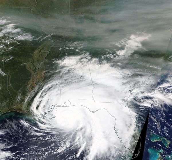
On September 15, 2020, the Moderate Resolution Imaging Spectroradiometer (MODIS) on board NASA’s Terra satellite acquired a true-color image of Hurricane Sally approaching the Gulf Coast as leading rain bands from the storm approach a broad band of smoke from the West Coast wildfires.
Sally made landfall at 5:45 a.m. EDT (0945 UTC) on September 16 near Gulf Shores, Alabama. According to the National Hurricane Center, the storm was carrying maximum sustained winds of about 104 mph (167.4 km/h) at landfall. That would place it as a Category 2 storm on the Saffir-Simpson Hurricane Wind Scale.
The slow-moving, drenching storm is a record-setter itself. Forming on September 12, it was the earliest-forming “S”- (18th-) named storm on record. The previous early storm was Stan, which formed on October 4, 2005. According to a meteorologist with Colorado State University, Sally is the 8th named storm to make landfall in the continental US (CONUS) in 2020, marking the most CONUS landfalls on record by September 16. The previous record was 7 named storms and was set in 1916.
By the evening of September 16, Sally had been downgraded to a tropical storm, with maximum sustained winds of 45 mph (72.4 km/h) and was located over southeastern Alabama. It is predicted to continue to weaken as it moves inland. With up to 30 inches of rain and extensive flooding reported in some locations, the National Weather Service states “historic and catastrophic flooding, including widespread moderate-to-major riving flooding, is unfolding along and just inland from west of Tallahassee, Florida to Mobile Bay, Alabama. Significant and widespread flooding is expected across inland portions of Alabama, central Georgia and upstate South Carolina, and widespread flooding is possible across western/central North Carolina and far southeast Virginia.
Image Facts
Satellite:
Terra
Date Acquired: 9/15/2020
Resolutions:
1km (564.9 KB), 500m (3.2 MB),
Bands Used: 1,4,3
Image Credit:
MODIS Land Rapid Response Team, NASA GSFC
The year 2020 will be remembered as a time of extremes, especially in the United States. Not only has the country grappled with a pandemic and political divisions, but also with record-setting fire and hurricane seasons.
A summer of record-setting heat on the West Coast – Death Valley, California set a record for the highest temperature ever recorded on Earth in August – left vegetation crisp and dry, ready to ignite at any spark. By mid-August, a siege of more than 1,000 lightning strikes caused fires across California and, to a lesser extent, sparked fires in Washington and Oregon. Strong, downslope winds and low humidity stoked small fires, turning them into blazing infernos. According to Cal Fire, five of the 20 largest fires in the state’s history have occurred since August, with the August Complex taking the number one position, with 796,651 acres burned, 26 structures destroyed, and 1 death as of September 16. Two of the current wildfires also made the list of California’s top 20 most deadly fires: The North Complex (22 dead) and LNU Lightning Complex with 5 killed. Washington registered its largest fire in history, the Cold Springs Canyon/Pearl Hill Fires, which has burned more than 400,000 acres. Likewise, Oregon reports its most destructive fire season on record, with more than 930,000 acres burnt and several towns destroyed. By September 15, smoke from these fires stretched over the entire United States, reaching the Atlantic Ocean.
While hot, dry weather ushered in the incredibly destructive West Coast fire season, the Atlantic Hurricane season was setting records for wet, windy storms. On September 14, the National Hurricane Center was reporting five tropical cyclones in the Atlantic Basin – only the second time in history that there have been five or more cyclones spinning simultaneously in this region. As of September 16, the 2020 season is tied with 1933 as the second most active on record, with 20 named storms, ranking only behind 2005, when there were 28 named storms in the entire season. Out of the 20 storms, 17 were the earliest occurring for their number. Tropical Storm Vicky, the 20th storm of the season, formed on September 14, beating the previous formation date for the 20th storm by 21 days.
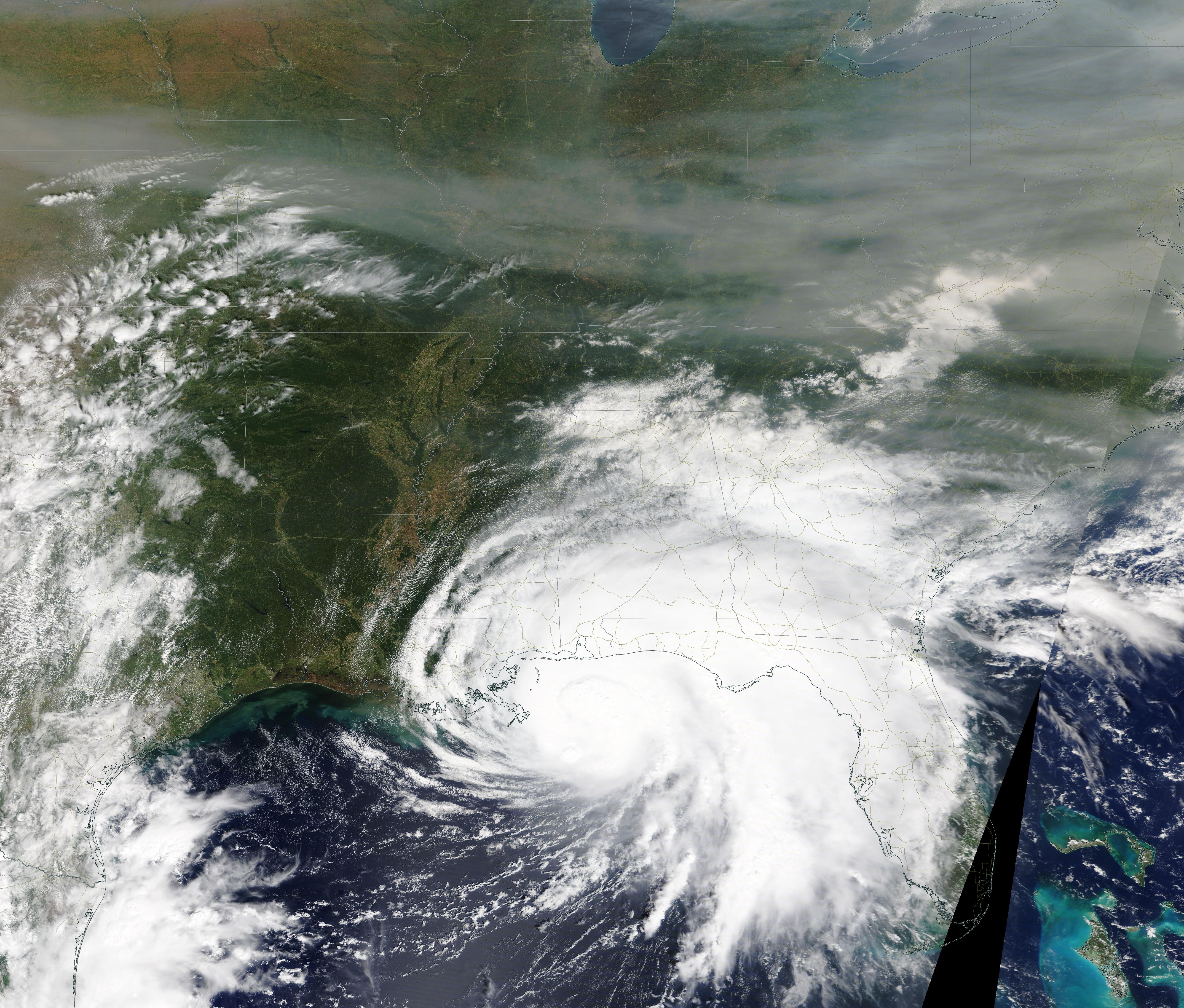
On September 15, 2020, the Moderate Resolution Imaging Spectroradiometer (MODIS) on board NASA’s Terra satellite acquired a true-color image of Hurricane Sally approaching the Gulf Coast as leading rain bands from the storm approach a broad band of smoke from the West Coast wildfires.
Sally made landfall at 5:45 a.m. EDT (0945 UTC) on September 16 near Gulf Shores, Alabama. According to the National Hurricane Center, the storm was carrying maximum sustained winds of about 104 mph (167.4 km/h) at landfall. That would place it as a Category 2 storm on the Saffir-Simpson Hurricane Wind Scale.
The slow-moving, drenching storm is a record-setter itself. Forming on September 12, it was the earliest-forming “S”- (18th-) named storm on record. The previous early storm was Stan, which formed on October 4, 2005. According to a meteorologist with Colorado State University, Sally is the 8th named storm to make landfall in the continental US (CONUS) in 2020, marking the most CONUS landfalls on record by September 16. The previous record was 7 named storms and was set in 1916.
By the evening of September 16, Sally had been downgraded to a tropical storm, with maximum sustained winds of 45 mph (72.4 km/h) and was located over southeastern Alabama. It is predicted to continue to weaken as it moves inland. With up to 30 inches of rain and extensive flooding reported in some locations, the National Weather Service states “historic and catastrophic flooding, including widespread moderate-to-major riving flooding, is unfolding along and just inland from west of Tallahassee, Florida to Mobile Bay, Alabama. Significant and widespread flooding is expected across inland portions of Alabama, central Georgia and upstate South Carolina, and widespread flooding is possible across western/central North Carolina and far southeast Virginia.
Image Facts
Satellite:
Terra
Date Acquired: 9/15/2020
Resolutions:
1km (564.9 KB), 500m (3.2 MB),
Bands Used: 1,4,3
Image Credit:
MODIS Land Rapid Response Team, NASA GSFC
