Images
September 19, 2020 - Hurricane Teddy
Tweet
Not only was Hurricane Teddy the earliest-forming 19th named storm of any Atlantic Hurricane season on record, it became the second-strongest Atlantic hurricane of 2020 on September 17 when it explosively intensified to become a Category 4 storm carrying maximum sustained winds of 140 mph (220 km/h). According to the United Nation’s World Meteorological Organization (WMO) Hurricane Laura maintained the title of strongest storm of the 2020 Atlantic season, with recorded peak 1-minute maximum sustained winds of 150 mph (240 km/h).
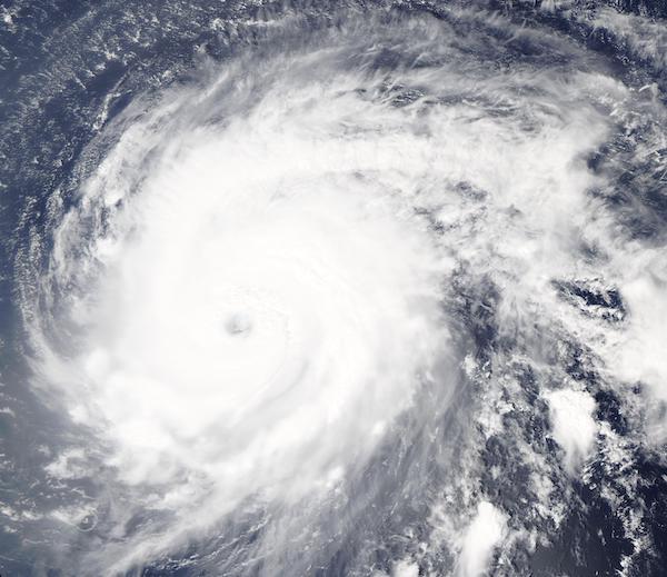
On September 17, 2020, the Moderate Resolution Imaging Spectroradiometer (MODIS) on board NASA’s Aqua satellite acquired a true-color image of Hurricane Teddy as it was strengthening over open ocean while tracking towards Bermuda. Heavy storm clouds circulated around a large, partially cloud-filled eye, giving Teddy the tight apostrophe-shape of strong storms.
Teddy began as Tropical Depression 20, which formed late on September 12 in the Central North Atlantic Ocean, about 2,030 miles (3,265 km) east of the Northern Leeward Islands. It maintained tropical depression status until September 14 when infrared satellite data helped confirm it had strengthened and organized into a Tropical Storm. After facing some wind shear, Teddy intensified into a hurricane on September 16.
At 11:00 a.m. EDT (1500 UTC) on September 18, the National Hurricane Center (NHC) advised that Hurricane Teddy was located about 525 miles (850 km) east northeast of the Northern Leeward Islands and about 885 mi (1,420 km) southeast of Bermuda. It was carrying maximum sustained winds of 130 mph (215 km/h) and was moving northwest at 12 mph (19 km/h).
Teddy is expected to approach Bermuda as a hurricane this weekend and make its closest approach to the island late on September 21-22. While the exact details of Teddy's track and intensity near
the island are not yet known, there is a risk strong winds, storm surge, and heavy rainfall on
Bermuda, and watches may be issued later today or tonight. Large swells produced by Teddy are expected to affect portions of the Leeward Islands, the Greater Antilles, the Bahamas, Bermuda, and the southeastern United States during the next few days. These swells could cause life-threatening surf and rip current conditions.
Image Facts
Satellite:
Aqua
Date Acquired: 9/17/2020
Resolutions:
1km (230.2 KB), 500m (746.5 KB), 250m (2 MB)
Bands Used: 1,4,3
Image Credit:
MODIS Land Rapid Response Team, NASA GSFC
Tweet
Not only was Hurricane Teddy the earliest-forming 19th named storm of any Atlantic Hurricane season on record, it became the second-strongest Atlantic hurricane of 2020 on September 17 when it explosively intensified to become a Category 4 storm carrying maximum sustained winds of 140 mph (220 km/h). According to the United Nation’s World Meteorological Organization (WMO) Hurricane Laura maintained the title of strongest storm of the 2020 Atlantic season, with recorded peak 1-minute maximum sustained winds of 150 mph (240 km/h).
On September 17, 2020, the Moderate Resolution Imaging Spectroradiometer (MODIS) on board NASA’s Aqua satellite acquired a true-color image of Hurricane Teddy as it was strengthening over open ocean while tracking towards Bermuda. Heavy storm clouds circulated around a large, partially cloud-filled eye, giving Teddy the tight apostrophe-shape of strong storms.
Teddy began as Tropical Depression 20, which formed late on September 12 in the Central North Atlantic Ocean, about 2,030 miles (3,265 km) east of the Northern Leeward Islands. It maintained tropical depression status until September 14 when infrared satellite data helped confirm it had strengthened and organized into a Tropical Storm. After facing some wind shear, Teddy intensified into a hurricane on September 16.
At 11:00 a.m. EDT (1500 UTC) on September 18, the National Hurricane Center (NHC) advised that Hurricane Teddy was located about 525 miles (850 km) east northeast of the Northern Leeward Islands and about 885 mi (1,420 km) southeast of Bermuda. It was carrying maximum sustained winds of 130 mph (215 km/h) and was moving northwest at 12 mph (19 km/h).
Teddy is expected to approach Bermuda as a hurricane this weekend and make its closest approach to the island late on September 21-22. While the exact details of Teddy's track and intensity near the island are not yet known, there is a risk strong winds, storm surge, and heavy rainfall on Bermuda, and watches may be issued later today or tonight. Large swells produced by Teddy are expected to affect portions of the Leeward Islands, the Greater Antilles, the Bahamas, Bermuda, and the southeastern United States during the next few days. These swells could cause life-threatening surf and rip current conditions.
Image Facts
Satellite:
Aqua
Date Acquired: 9/17/2020
Resolutions:
1km (230.2 KB), 500m (746.5 KB), 250m (2 MB)
Bands Used: 1,4,3
Image Credit:
MODIS Land Rapid Response Team, NASA GSFC


