
Images


April 12, 2021 - Spring in the North Adriatic Sea
 Tweet
Tweet
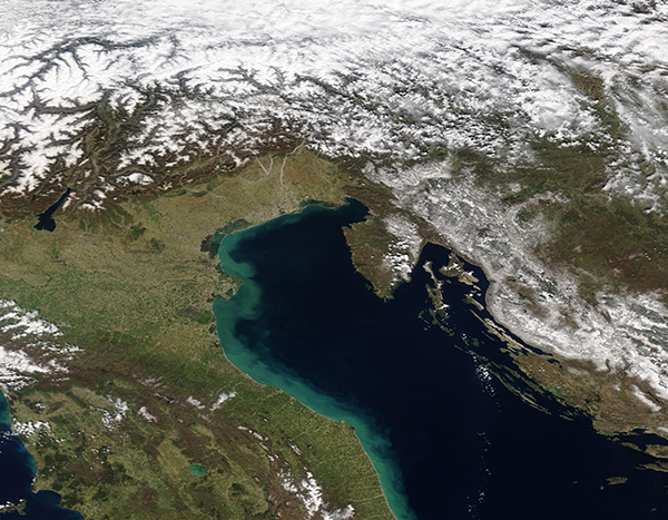
A halo of tan and green sediment hugged the shores of Italy, staining the bright blue waters of the northern Adriatic Sea in early April 2021. The Moderate Resolution Imaging Spectroradiometer (MODIS) on board NASA’s Terra satellite acquired this true-color image on April 8.
The Adriatic Sea is the northernmost arm of the Mediterranean Sea, separating the Italian Peninsula from the Balkans. Italy sits along the western coast of the Adriatic and, in this image, Slovenia can be seen in the northeast and Croatia in the east. Many islands sit off the mainland of Croatia and the waters are deep; the waters are shallower off of Italy and few islands exist.
The suspended sediment probably comes from run-off after spring rains, from tidal action bringing sediment up from a relatively shallow bottom, and from the substantial amount of sediment that is washed into the Adriatic from several large rivers that pour into the northwestern section of the Sea. These rivers, particularly the Po and Adige Rivers, carry melt water and sediment from the Apennine Mountains and the Alps as well as fill with spring rains. Snow still covers both the high Alps (north) and Apennines (west), although warming temperatures have already started a vigorous spring melt.
Image Facts
Satellite:
Terra
Date Acquired: 4/8/2021
Resolutions:
1km (440.2 KB), 500m (1.1 MB), 250m (857.3 KB)
Bands Used: 1,4,3
Image Credit:
MODIS Land Rapid Response Team, NASA GSFC
