
Images


June 19, 2021 - Color in the Northern Caspian Sea
 Tweet
Tweet
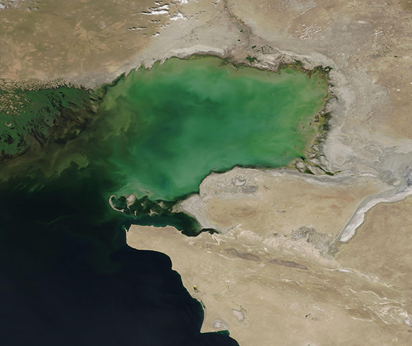
Swirls of green and tan stained the northeastern Caspian Sea on June 17, 2021, when the Moderate Resolution Imaging Spectroradiometer (MODIS) on board NASA’s Terra satellite acquired a true-color image of the region.
The Caspian Sea is the world’s largest landlocked body of water. Stretching 1,200 kilometers (750 miles) from north to south, it intersects five countries in Asia and Europe, with Kazakhstan wrapped around the northeastern corner of the large landlocked lake.
While the water is deep in the southern and central portions of the Caspian Sea, the northern section overlies a shelf, making it very shallow. The north receives heavy freshwater inflow from the large Volga River and from the Ural River. The Ural can be seen at the top of this image, but the Volga sits to the west (left). Both rivers carry sediment into the Sea and their inflow creates currents that can lift sediment from the muddy bottom and carry it in swirls along with the current. Heavy wind may also stir the shallow waters and lift sediment.
Sediment appears tan or mud-colored where it floats close to the surface, as can be seen along the coastline. As sediment sinks, its reflectivity changes and this causes it to appear green in true-color MODIS images. While most of the color in the northeastern Caspian Sea is likely sediment, it’s not possible to rule out the presence of phytoplankton with true-color imagery. These microscopic plant-like organisms sometimes reproduce so explosively that they can tint the water in greens or blues.
Image Facts
Satellite:
Terra
Date Acquired: 6/17/2021
Resolutions:
1km (256.4 KB), 500m (689.4 KB), 250m (368.1 KB)
Bands Used: 1,4,3
Image Credit:
MODIS Land Rapid Response Team, NASA GSFC
Swirls of green and tan stained the northeastern Caspian Sea on June 17, 2021, when the Moderate Resolution Imaging Spectroradiometer (MODIS) on board NASA’s Terra satellite acquired a true-color image of the region.
The Caspian Sea is the world’s largest landlocked body of water. Stretching 1,200 kilometers (750 miles) from north to south, it intersects five countries in Asia and Europe, with Kazakhstan wrapped around the northeastern corner of the large landlocked lake. While the water is deep in the southern and central portions of the Caspian Sea, the northern section overlies a shelf, making it very shallow. The north receives heavy freshwater inflow from the large Volga River and from the Ural River. The Ural can be seen at the top of this image, but the Volga sits to the west (left). Both rivers carry sediment into the Sea and their inflow creates currents that can lift sediment from the muddy bottom and carry it in swirls along with the current. Heavy wind may also stir the shallow waters and lift sediment.
Sediment appears tan or mud-colored where it floats close to the surface, as can be seen along the coastline. As sediment sinks, its reflectivity changes and this causes it to appear green in true-color MODIS images. While most of the color in the northeastern Caspian Sea is likely sediment, it’s not possible to rule out the presence of phytoplankton with true-color imagery. These microscopic plant-like organisms sometimes reproduce so explosively that they can tint the water in greens or blues.
Image Facts
Satellite:
Terra
Date Acquired: 6/17/2021
Resolutions:
1km (256.4 KB), 500m (689.4 KB), 250m (368.1 KB)
Bands Used: 1,4,3
Image Credit:
MODIS Land Rapid Response Team, NASA GSFC
