
Images


September 17, 2021 - Flooding along the Brahmaputra River
 Tweet
Tweet
India’s monsoon season, which typically begins in June and ends in September, has been called a “four-month festival of rains”, a nod to the benefits that rain brings to farmers, fishermen, industry and even the average person who drinks water or bathes in it. In a typical year, the monsoon season gives India about 80 percent of its annual precipitation. Although there is joy and abundance in the refreshing rains, the long season of heavy downpours also brings the risk of flooding to both India and Bangladesh, especially along the rivers that overflow each season.
The 2021 monsoon season has been inconsistent, with most of August relatively dry across much of India. By early September, however, rainfall became near-record breaking in some locations. For example, on September 17, India Today reported that Delhi, India has already registered the second-highest totals for September ever recorded in that city, with 404.1 mm (16 in) measured. The highest rainfall previously recorded in Delhi was 417.3mm (16.4 in) in 1944—and that was for the entire month of September. This leaves only 13.2 mm (0.52 in) of rain that needs to fall in 14 days to break that record.
The heavy September rain helped swell the rivers of the region and brought flooding to both India and Bangladesh. On September 15, ReliefWeb reported that heavy rains and widespread floods were affecting six Districts of Gujarat State (western India), causing casualties and damage, including the overflow of the Lodhika Dam. As of September 14, seven people had perished, 4,900 people had been evacuated and at least 850,000 people affected in this region. On September 3, the International Federation of Red Cross and Red Crescent Societies (IFRC) reported that 3,600 people had been displaced in Bangladesh, with 454,712 people affected. On September 13, local media reported that, among other consequences of the floods, that 24 primary schools had been inundated in the low-lying town area of Rajbari, Bangladesh, affecting about 5,000 children.
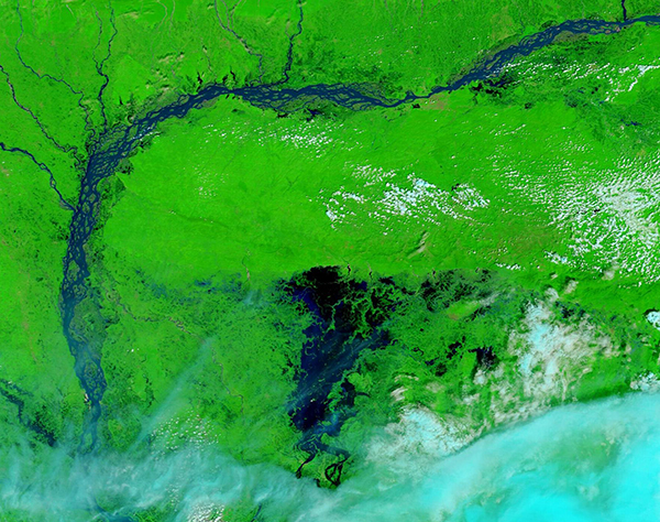
On September 10, 2021, the Moderate Resolution Imaging Spectroradiometer (MODIS) on board NASA’s Aqua satellite acquired a false-color image of flooding along the Brahmaputra River in India. In this type of image, infrared and visible light are used to create a view showing water as dark blue or black in contrast to the bright green plant-covered land. Clouds appear white or light blue. When seen from above by human eyes—or in a true-color image—the muddy water and the land would blend together, but this combination of light, not normally seen by people, creates contrast between water and land.
While this single image gives an impressive view of broad areas of water inundating vegetated land, to better appreciate the extent of the floodwaters it is helpful to compare two MODIS images of the same area, one acquired prior to the floods and this one. Thanks to the NASA Worldview App, it’s easy to see such a comparison. To view a roll-over of images acquired on March 4, 2021, and this one acquired on September 10, 2021, click
here. The difference between the two dates is truly astounding.
Image Facts
Satellite:
Aqua
Date Acquired: 9/10/2021
Resolutions:
1km (255.1 KB), 500m (746.1 KB), 250m (2.1 MB)
Bands Used: 7,2,1
Image Credit:
MODIS Land Rapid Response Team, NASA GSFC
India’s monsoon season, which typically begins in June and ends in September, has been called a “four-month festival of rains”, a nod to the benefits that rain brings to farmers, fishermen, industry and even the average person who drinks water or bathes in it. In a typical year, the monsoon season gives India about 80 percent of its annual precipitation. Although there is joy and abundance in the refreshing rains, the long season of heavy downpours also brings the risk of flooding to both India and Bangladesh, especially along the rivers that overflow each season.
The 2021 monsoon season has been inconsistent, with most of August relatively dry across much of India. By early September, however, rainfall became near-record breaking in some locations. For example, on September 17, India Today reported that Delhi, India has already registered the second-highest totals for September ever recorded in that city, with 404.1 mm (16 in) measured. The highest rainfall previously recorded in Delhi was 417.3mm (16.4 in) in 1944—and that was for the entire month of September. This leaves only 13.2 mm (0.52 in) of rain that needs to fall in 14 days to break that record.
The heavy September rain helped swell the rivers of the region and brought flooding to both India and Bangladesh. On September 15, ReliefWeb reported that heavy rains and widespread floods were affecting six Districts of Gujarat State (western India), causing casualties and damage, including the overflow of the Lodhika Dam. As of September 14, seven people had perished, 4,900 people had been evacuated and at least 850,000 people affected in this region. On September 3, the International Federation of Red Cross and Red Crescent Societies (IFRC) reported that 3,600 people had been displaced in Bangladesh, with 454,712 people affected. On September 13, local media reported that, among other consequences of the floods, that 24 primary schools had been inundated in the low-lying town area of Rajbari, Bangladesh, affecting about 5,000 children.
On September 10, 2021, the Moderate Resolution Imaging Spectroradiometer (MODIS) on board NASA’s Aqua satellite acquired a false-color image of flooding along the Brahmaputra River in India. In this type of image, infrared and visible light are used to create a view showing water as dark blue or black in contrast to the bright green plant-covered land. Clouds appear white or light blue. When seen from above by human eyes—or in a true-color image—the muddy water and the land would blend together, but this combination of light, not normally seen by people, creates contrast between water and land.
While this single image gives an impressive view of broad areas of water inundating vegetated land, to better appreciate the extent of the floodwaters it is helpful to compare two MODIS images of the same area, one acquired prior to the floods and this one. Thanks to the NASA Worldview App, it’s easy to see such a comparison. To view a roll-over of images acquired on March 4, 2021, and this one acquired on September 10, 2021, click here. The difference between the two dates is truly astounding.
Image Facts
Satellite:
Aqua
Date Acquired: 9/10/2021
Resolutions:
1km (255.1 KB), 500m (746.1 KB), 250m (2.1 MB)
Bands Used: 7,2,1
Image Credit:
MODIS Land Rapid Response Team, NASA GSFC
