
Images


September 18, 2021 - Typhoon Chanthu
 Tweet
Tweet
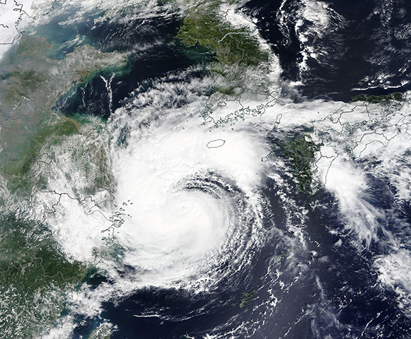
On September 16, 2021, Typhoon Chanthu was spinning over the East China Sea when the Moderate Resolution Imaging Spectroradiometer (MODIS) aboard NASA’s Terra satellite acquired a true-color image of the storm. At 0000 UTC on September 16 (8:00 p.m. EDT September 15), the center of the storm was located about 330 km (205 mi) southwest of Jeju Island, South Korea and 410 km (255 mi) southwest of Goto Islands, Japan. Maximum sustained winds were reported at about 64 mph (102 km/h) and the storm was tracking towards Japan.
Typhoon Chanthu made landfall on Kyushu Island in southwestern Japan on September 17, carrying maximum sustained winds of about 46 mph (74 km/h). This placed it as a tropical storm on the Saffir-Simpson Hurricane Wind Scale. Local media reported heavy wind, strong surf, widespread power outages and at least five people injured by the storm.
At 2100 UTC (5:00 p.m. EDT) on September 17, the Joint Typhoon Warning Center (JTWC) advised that Chanthu was now a tropical depression located 194.5 mi (313 km) west-southwest of Yokosuka, Japan and was tracking eastward. Maximum sustained winds were estimated at about 28.8 mph (46 km/h) with higher gusts. The storm is expected to continue to weaken as it moves eastward over Shikoku Island and over southern Honshu Island before reaching the Pacific Ocean.
Image Facts
Satellite:
Terra
Date Acquired: 9/16/2021
Resolutions:
1km (741 KB), 500m (2.4 MB),
Bands Used: 1,4,3
Image Credit:
MODIS Land Rapid Response Team, NASA GSFC
