
Images


December 1, 2021 - The Beautiful and Blue Bass Strait
 Tweet
Tweet
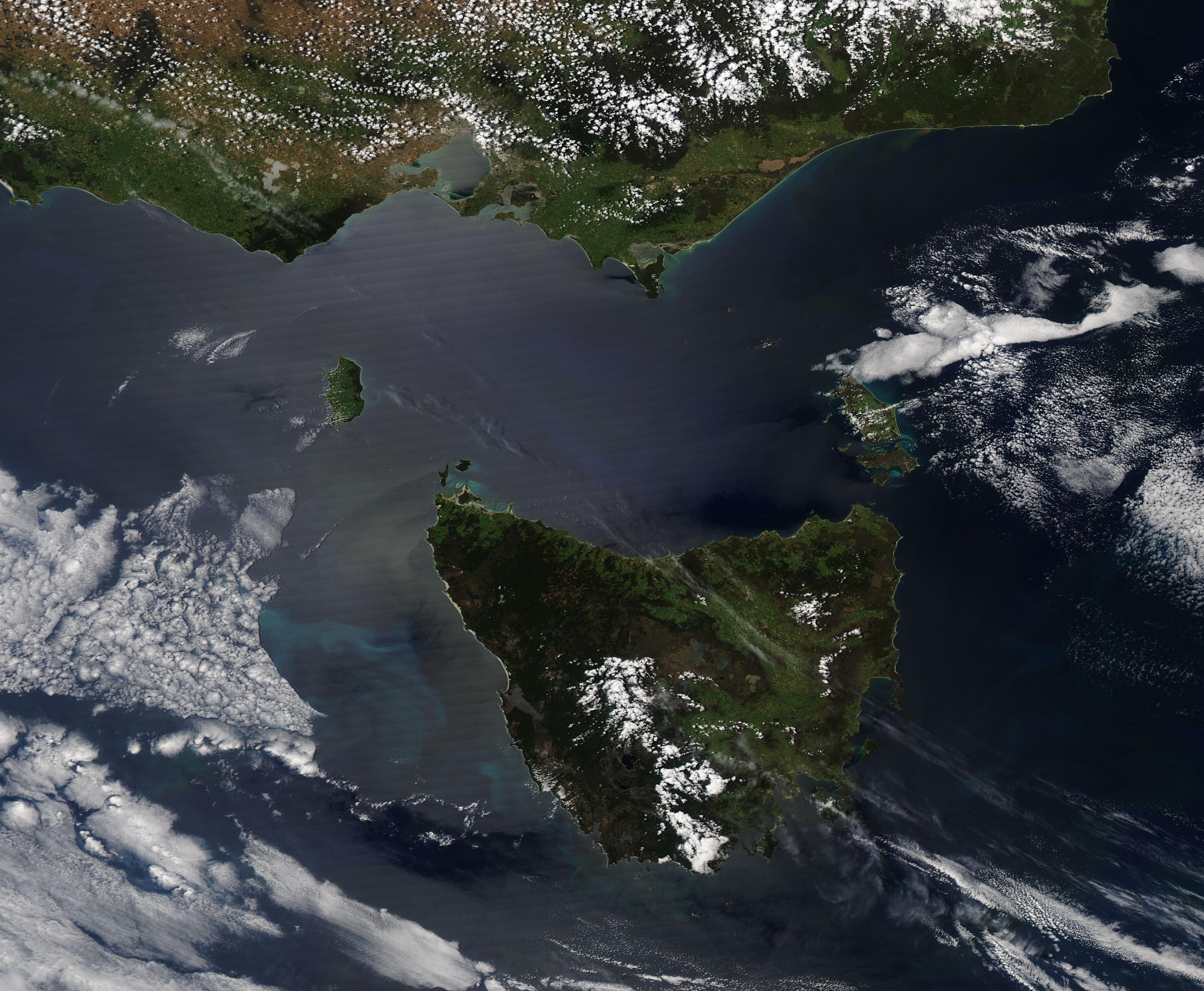
South of the Australian state of Victoria, the blue waters and roiling waves of Bass Strait create a wild and daunting challenge to sailors who want to reach the island of Tasmania. Only about 150 miles (240 km) wide at its narrowest point and about 164 feet (50 meters) deep, the strait is dotted with 50 islands, many semi-submerged reefs and rocks, and subject to strong, gusting winds.
Although the strait enjoys busy marine commerce today, the passage once developed a reputation for mysterious disappearances of both ships and aircraft. In fact, in some circles, it was called “the Bass Strait Triangle”, a nod to the legends of piracy, disappearances that leave no trace, and alleged supernatural phenomena similar to those rumored to occur at the more famous Bermuda Triangle.
One incident that inspired paranormal speculation was the disappearance of Frederick Valentich in 1978. He was flying in a Cessna 182L light aircraft on a training flight over the Bass Strait. He was heading toward King Island when he reported to a local airport that he saw an aircraft below his plane, which subsequently flew over him several times. He could not identify what it was, saying it had four lights, was shiny and long. It is said that stated the "strange" object moved to the front of the plane, then hovered over him. The airport personnel heard an odd sound, described either as "scraping" or "pulsing", followed by silence. Neither the plane nor Valentich was ever seen again.
While such stories are great for shivers and speculation, the fact is that very few ships or planes have been lost over the Bass Strait with no known reason. The howling winds of the “roaring forties” create nearly unpredictable and sometimes sudden turbulence, especially as they bounce off the taller islands. Such winds create treacherous conditions, both in the air and at sea. Under-experienced pilots and crew faced with extreme conditions are the cause of most air crashes and ship sinkings in the Bass Strait. Today, loss of vessels in the busy shipping lanes is very rare, and many aircraft routinely (and safely) navigate the airways on a daily basis.
The Moderate Resolution Imaging Spectroradiometer (MODIS) on board NASA’s Aqua satellite acquired a true-color image of the Bass Strait on November 29, 2021. Some idea of the complex wind patterns can be gained through the various cloud patterns. To the west of Tasmania, a large bank of cloud appears to align on a northwest-to-southeast axis and the leading edge stops abruptly roughly parallel to the western coastline, leaving a wide swath of clear air carved by changing wind patterns. Within Bass Strait, streaks of cloud curve from the southwest to the northeast on the west side of King Island, while ripples of cloud can be seen in the air southeast of the island, then streaks of wind-driven cloud turns nearly 180 degrees to pass over Tasmania. Meanwhile, on the eastern side of Bass Strait near Flinders Island, the clouds stretch more easterly and appear as if they are floating in relatively quiet sky. Parallel streaks seen close to the coast of Victoria are imaging artifacts and are not created by wind or wave.
Image Facts
Satellite:
Aqua
Date Acquired: 11/29/2021
Resolutions:
1km (246.5 KB), 500m (606.4 KB), 250m (1.6 MB)
Bands Used: 1,4,3
Image Credit:
MODIS Land Rapid Response Team, NASA GSFC
South of the Australian state of Victoria, the blue waters and roiling waves of Bass Strait create a wild and daunting challenge to sailors who want to reach the island of Tasmania. Only about 150 miles (240 km) wide at its narrowest point and about 164 feet (50 meters) deep, the strait is dotted with 50 islands, many semi-submerged reefs and rocks, and subject to strong, gusting winds. Although the strait enjoys busy marine commerce today, the passage once developed a reputation for mysterious disappearances of both ships and aircraft. In fact, in some circles, it was called “the Bass Strait Triangle”, a nod to the legends of piracy, disappearances that leave no trace, and alleged supernatural phenomena similar to those rumored to occur at the more famous Bermuda Triangle.
One incident that inspired paranormal speculation was the disappearance of Frederick Valentich in 1978. He was flying in a Cessna 182L light aircraft on a training flight over the Bass Strait. He was heading toward King Island when he reported to a local airport that he saw an aircraft below his plane, which subsequently flew over him several times. He could not identify what it was, saying it had four lights, was shiny and long. It is said that stated the "strange" object moved to the front of the plane, then hovered over him. The airport personnel heard an odd sound, described either as "scraping" or "pulsing", followed by silence. Neither the plane nor Valentich was ever seen again.
While such stories are great for shivers and speculation, the fact is that very few ships or planes have been lost over the Bass Strait with no known reason. The howling winds of the “roaring forties” create nearly unpredictable and sometimes sudden turbulence, especially as they bounce off the taller islands. Such winds create treacherous conditions, both in the air and at sea. Under-experienced pilots and crew faced with extreme conditions are the cause of most air crashes and ship sinkings in the Bass Strait. Today, loss of vessels in the busy shipping lanes is very rare, and many aircraft routinely (and safely) navigate the airways on a daily basis.
The Moderate Resolution Imaging Spectroradiometer (MODIS) on board NASA’s Aqua satellite acquired a true-color image of the Bass Strait on November 29, 2021. Some idea of the complex wind patterns can be gained through the various cloud patterns. To the west of Tasmania, a large bank of cloud appears to align on a northwest-to-southeast axis and the leading edge stops abruptly roughly parallel to the western coastline, leaving a wide swath of clear air carved by changing wind patterns. Within Bass Strait, streaks of cloud curve from the southwest to the northeast on the west side of King Island, while ripples of cloud can be seen in the air southeast of the island, then streaks of wind-driven cloud turns nearly 180 degrees to pass over Tasmania. Meanwhile, on the eastern side of Bass Strait near Flinders Island, the clouds stretch more easterly and appear as if they are floating in relatively quiet sky. Parallel streaks seen close to the coast of Victoria are imaging artifacts and are not created by wind or wave.
Image Facts
Satellite:
Aqua
Date Acquired: 11/29/2021
Resolutions:
1km (246.5 KB), 500m (606.4 KB), 250m (1.6 MB)
Bands Used: 1,4,3
Image Credit:
MODIS Land Rapid Response Team, NASA GSFC
