
Images


December 4, 2021 - Color around Hainan Island, China
 Tweet
Tweet
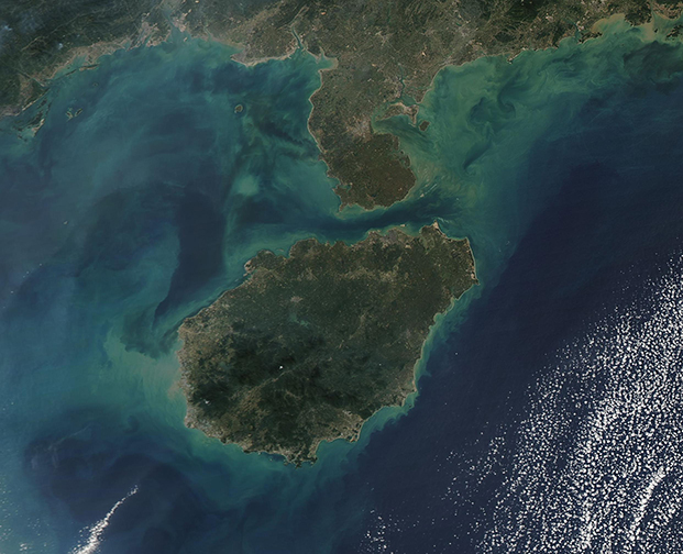
Hainan Island has been called “China’s largest tropical island”, thanks to its wealth of warm weather and sandy beaches. Sitting south of Guangdong Province on China’s mainland, Hainan Island measures about 12,700 square miles (32,900 square km) and is the largest island in Hainan Province. The province itself is made up of about 200 small islands, which make up only about 3 percent of the land mass. Hainan Island encompasses the other 97 percent.
On December 3, 2021, the Moderate Resolution Imaging Spectroradiometer (MODIS) on board NASA’s Aqua satellite acquired a true-color image of Hainan Island. To the north, the island is separated from the Leizhou Peninsula by the Qiongzhou Strait. The waters of the South China Sea surround the rest of Hainan.
Dramatic swirls of tans, greens, and blues stain the waters off the southern coast of the mainland and off of Hainan Island. The color appears to come primarily from sediment, which has been washed into the South China Sea from the land or spilled into it from the many rivers that feed into the Sea. Sediment appears a muddy tan when it floats at the surface, most typically near shorelines, which can be seen in this image. As sediment sinks and disperses, the reflectivity changes so the color as seen from above also changes, first to green and then to shades of blue. It is possible that some color may also come from blooms of floating, plant-like organisms known as phytoplankton.
Image Facts
Satellite:
Aqua
Date Acquired: 12/3/2021
Resolutions:
1km (263.7 KB), 500m (690.6 KB), 250m (413.6 KB)
Bands Used: 1,4,3
Image Credit:
MODIS Land Rapid Response Team, NASA GSFC
