
Images


May 13, 2022 - Thawing around Akimiski Island
 Tweet
Tweet
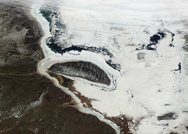
On May 11, 2022, the Moderate Resolution Imaging Spectroradiometer (MODIS) on board NASA’s Terra satellite acquired a true-color image of ice breakup near Akimiski Island, St. James Bay in Nunavut, Canada. The crescent-shaped island is the largest in James Bay, with an area of about 1,159 square miles (3,000 square km). Although currently uninhabited, it has an important history as part of the Attawapiskat First Nation’s traditional territory and is also recognized as an IBA (Important Bird and Biodiversity Area) by BirdLife International. Hundreds of thousands of birds flock to the island during migration, and at least 10,000 of the Southern James Bay Canada Goose population breeds on the island as well as other species. In addition, the southern region of Akimiski Island is a maternity denning area and the coasts are a summer retreat for polar bears.
The importance of the island to the to the First Nation’s peoples cannot be underestimated. The division of the island from the province of Ontario, where the tribes reside, as well part of the island being owned by the federal government and identified as the Akimiski Island Migratory Bird Sanctuary has made it difficult for the leaders to assert territorial rights to hunting and trapping on the land. However, the western third of the island is unregulated and is used by the First Nation’s peoples as has been tradition. One tradition is that each May, as the air temperature warms but while the ice remains strong, hunters from the tribe cross the ice from the Ontario mainland to reach Akimiski, looking to find food. Because the ice can thaw quickly and unexpectedly, this important foray is fraught with danger. One misstep on the weakening ice can bring disaster.
To better understand how quickly ice can melt around Akimiski, the NASA Worldview app offers a comparison of two Terra MODIS images acquired on two different dates. To view this comparison, which shows an image acquired on April 29 and the image above, acquired less than two weeks later on May 11, simply click here.
NASA's Earth Observing System Data and Information System (EOSDIS) Worldview application provides the capability to interactively browse over 700 global, full-resolution satellite imagery layers and then download the underlying data. Many of the available imagery layers are updated within three hours of observation, essentially showing the entire Earth as it looks "right now".
Image Facts
Satellite:
Terra
Date Acquired: 5/11/2022
Resolutions:
1km (165.2 KB), 500m (453.2 KB), 250m (314.5 KB)
Bands Used: 1,4,3
Image Credit:
MODIS Land Rapid Response Team, NASA GSFC
