
Images


October 1, 2022 - Lazy Fire in Texas
 Tweet
Tweet
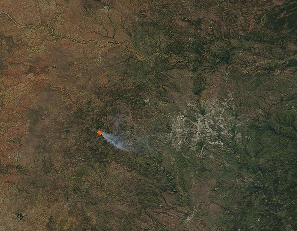
A hot, dry spring and summer sparked a difficult wildfire season across Texas in 2022. According to the Texas A&M Forest Service, as of September 28 state and local firefighters have responded to more than 9,800 wildfires across the Lone Star State this year—and 65 wildfires this past week. While most of the recent wildfires have been rapidly contained, one notable fire expanded rapidly.
The Moderate Resolution Imaging Spectroradiometer (MODIS) on board NASA’s Terra satellite acquired a true-color image of Central Texas and the Lazy Fire on September 29, 2022. The actively burning fire is marked by a large red “hot spot” that is accompanied by a thick gray plume of smoke blowing from the fire to the southeast. Gray pixels, arranged to look almost like a spider web on a background of green, are man-made structures of the Dallas-Fort Worth metro area.
According to a report on InciWeb Incident Information System, Texas A&M Forest Service first received a request for assistance on a wildfire burning in Palo Pinto County on September 29. Located 6 miles south of Possum Kingdom Lake and west of State Highway 16, the Lazy Fire is burning in rough terrain with thick juniper vegetation and is threatening multiple structures. As of September 30, the fire expanded rapidly and is burning on 1,500 acres. Fire fighters are working on full suppression, with protection of assets and have brought the Lazy Fire to 45 percent containment. The fire was first reported as a prescribed burn that escaped control, but the fire’s origin is undergoing investigation.
Image Facts
Satellite:
Terra
Date Acquired: 9/29/2022
Resolutions:
1km (45 KB), 500m (178.9 KB), 250m (599.9 KB)
Bands Used: 1,4,3
Image Credit:
MODIS Land Rapid Response Team, NASA GSFC
