
Images


October 3, 2022 - Flooding in Florida
Tweet
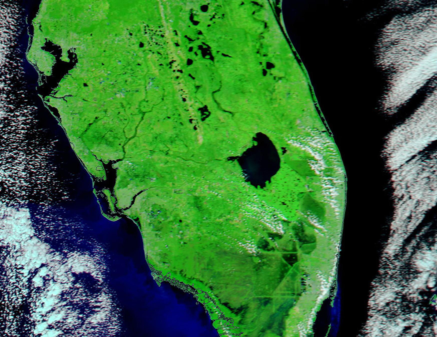
After crashing across the Caribbean, causing damage in Jamaica, Cayman Islands, and Cuba, Hurricane Ian made landfall in southwestern Florida on September 28, 2022, as a strong Category 4 storm, carrying maximum sustained winds of 150 mph (241 km/h). Over the next twenty-four hours Ian ground across the Florida Peninsula, slowly weakening in strength as it deposited record rainfall across the state. According to the National Hurricane Center (NHC), Ian moved off the Florida coast near Cape Canaveral and moved over the western Atlantic Ocean at 11:00 a.m. EST on September 29 after producing “catastrophic flooding” over much of the state.
Our Image of the Day illustrates widespread and devastating flooding in Florida by comparing two false-color images acquired by the Moderate Resolution Imaging Spectroradiometer (MODIS) on board NASA’s Terra satellite. The first image, located on the left, was acquired after the storm on September 30, 2022. The second was acquired a week earlier, on September 23. To interact with this roll-over comparison, click on the image and scroll back and forth.
In this type of false-color image, visible and infrared light (MODIS bands 7,2,1) are combined to help highlight certain features, such as water and vegetation. Vegetation appears bright green, water looks deep blue, cloud may appear white or be tinted with light electric blue, and open land may be colored various shades of tan. Where dense vegetation is water-logged (rather than under water), the color becomes darker green.
Hurricane Ian first made landfall in Florida near Cayo Costa, an island near Fort Meyers, then made a second landfall near Punta Gorda. These areas can be seen on the southwestern Florida coast, almost due west of the large, round Lake Okeechobee. The points of impact include the large Gasparilla Sound-Charlotte Harbor (where the Peace River empties into the Gulf of Mexico), the large Pine Island, and the barrier islands including Sanibel Island (curving around the southern section of Pine Island), Captiva Island, and Cayo Costa.
Much of the area located near landfall was drowned under storm surge of seven feet or more; however, by September 30 the storm surge had receded and cannot be seen on the image acquired that day. Major flooding is obvious along the Peace River, which crested at a record-setting 25.26 feet after the storm. Orlando, which sits well inland and along the northeasterly track of Ian, received 12.49 inches of rain between September 28 and 29, crushing that city’s 24-hour rainfall record. The Weather Channel reported that up to 19 inches of rain had fallen in parts of Florida in Ian’s wake.
Image Facts
Satellite:
Terra
Date Acquired: 9/30/3033
Resolutions:
1km (241.4 KB), 500m (576.1 KB), 250m (346.7 KB)
Bands Used: 7.2.1
Image Credit:
MODIS Land Rapid Response Team, NASA GSFC
Tweet
After crashing across the Caribbean, causing damage in Jamaica, Cayman Islands, and Cuba, Hurricane Ian made landfall in southwestern Florida on September 28, 2022, as a strong Category 4 storm, carrying maximum sustained winds of 150 mph (241 km/h). Over the next twenty-four hours Ian ground across the Florida Peninsula, slowly weakening in strength as it deposited record rainfall across the state. According to the National Hurricane Center (NHC), Ian moved off the Florida coast near Cape Canaveral and moved over the western Atlantic Ocean at 11:00 a.m. EST on September 29 after producing “catastrophic flooding” over much of the state.
Our Image of the Day illustrates widespread and devastating flooding in Florida by comparing two false-color images acquired by the Moderate Resolution Imaging Spectroradiometer (MODIS) on board NASA’s Terra satellite. The first image, located on the left, was acquired after the storm on September 30, 2022. The second was acquired a week earlier, on September 23. To interact with this roll-over comparison, click on the image and scroll back and forth.
In this type of false-color image, visible and infrared light (MODIS bands 7,2,1) are combined to help highlight certain features, such as water and vegetation. Vegetation appears bright green, water looks deep blue, cloud may appear white or be tinted with light electric blue, and open land may be colored various shades of tan. Where dense vegetation is water-logged (rather than under water), the color becomes darker green.
Hurricane Ian first made landfall in Florida near Cayo Costa, an island near Fort Meyers, then made a second landfall near Punta Gorda. These areas can be seen on the southwestern Florida coast, almost due west of the large, round Lake Okeechobee. The points of impact include the large Gasparilla Sound-Charlotte Harbor (where the Peace River empties into the Gulf of Mexico), the large Pine Island, and the barrier islands including Sanibel Island (curving around the southern section of Pine Island), Captiva Island, and Cayo Costa.
Much of the area located near landfall was drowned under storm surge of seven feet or more; however, by September 30 the storm surge had receded and cannot be seen on the image acquired that day. Major flooding is obvious along the Peace River, which crested at a record-setting 25.26 feet after the storm. Orlando, which sits well inland and along the northeasterly track of Ian, received 12.49 inches of rain between September 28 and 29, crushing that city’s 24-hour rainfall record. The Weather Channel reported that up to 19 inches of rain had fallen in parts of Florida in Ian’s wake.
Image Facts
Satellite:
Terra
Date Acquired: 9/30/3033
Resolutions:
1km (241.4 KB), 500m (576.1 KB), 250m (346.7 KB)
Bands Used: 7.2.1
Image Credit:
MODIS Land Rapid Response Team, NASA GSFC
