
Images


August 11, 2024 - Fluctuating Water Levels in Iraq


August 8, 2024
August 8, 2020
August 8, 2019
Tweet
Over the past several decades, water levels have fluctuated in lakes, rivers, and wetlands across the Middle East, making the region, combined with Northern Africa, the most water-stressed region on Earth. According to the Carnegie Endowment for International Peace, sixteen of the twenty-five most water-stressed countries in the world are in the Middle East-North Africa (MENA) region. Bahrain currently holds first place, and Iraq ranks as 23rd.
Water stress is defined as the gap between water supply and water demand. In other words, the most water stressed countries are using almost all of their available water. When water supply fluctuates, it can trigger severe water shortages in water-stressed countries.
The arid climate of Iraq is a fundamental cause of water scarcity in that country. However, the Tigris and Euphrates Rivers have been a historically reliable source of water for Iraq. Both rivers rise in the mountains of eastern Türkiye, pass through Syria and most of Iraq before merging to form the Shatt al-Arab, which flows to the Arabian Gulf. In Iraq, these rivers also fill numerous lakes and wetlands.
The availability of water is, of course, essential for life and livelihoods. In the past, many of Iraq’s lakes and wetlands hosted tourist towns and rich fishing industries. However, available water has been on a decreasing trend over time, due to overuse and misuse of water resources, reduced flow from dams upstream, increasing population, and increasing industrial water needs. More recently, extreme high temperatures and unreliable and decreasing rainfall brought about by climate warming has added to water fluctuation in Iraq as well as in the MENA region.
Today’s Image of the Day compares three true-color Moderate Resolution Imaging Spectroradiometer (MODIS) images of Iraq acquire by NASA’s Terra satellite on August 8 in three different years—2024, 2020, and 2019. Each image can be viewed by clicking on the corresponding date.
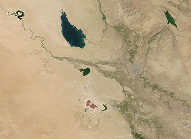
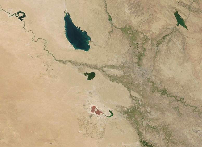
The largest lake is Lake Tharthar, fed by the Tigris River which can be seen in the northeast. The Euphrates feeds Lake Habbaniya and the smaller Lake Razzaza. In addition, Lake Qadisiyah, a man-made reservoir created by damming the Euphrates, can be seen in the upper left corner. The city of Fallujah sits on the Euphrates near Lake Razzaza. About 69 kilometers (43 miles) to the east of Fallujah is Iraq’s capital city, Baghdad. Baghdad is located on the Tigris River.
Viewing the region over time illustrates that, while the trend is towards decreasing water, significant fluctuation occurs from year to year. Clicking through the images, the impression is that August 8, 2024, shows the driest conditions. All waterways appear shrunken, especially Lake Razzaza which not only looks shriveled but shows a rim of crusted mineral salts and is tinted red from saline-loving bacteria. Lake Qadisiyah appears narrow, not much wider than the Euphrates itself.
The scene is quite similar on August 8, 2019, another dry years. Some areas seem to have more water in 2019 than in 2024, but a few others appear to be marginally wetter. Clicking on the August 8, 2020, image reveals much more water in all rivers and lakes and more wetland is apparent. These conditions were brought on by a wetter spring and summer. Note that Lake Razzaza appears larger and is blue, with no hint of red in 2020. Also, Lake Qadisiyah appears nearly double the size in either 2024 or 2019.
Image Facts
Satellite:
Terra
Date Acquired: 8/8/2024
Resolutions:
1km (41 KB), 500m (99.2 KB), 250m (152.5 KB)
Bands Used: 1,4,3
Image Credit:
MODIS Land Rapid Response Team, NASA GSFC
August 8, 2024 August 8, 2020 August 8, 2019
Over the past several decades, water levels have fluctuated in lakes, rivers, and wetlands across the Middle East, making the region, combined with Northern Africa, the most water-stressed region on Earth. According to the Carnegie Endowment for International Peace, sixteen of the twenty-five most water-stressed countries in the world are in the Middle East-North Africa (MENA) region. Bahrain currently holds first place, and Iraq ranks as 23rd.
Water stress is defined as the gap between water supply and water demand. In other words, the most water stressed countries are using almost all of their available water. When water supply fluctuates, it can trigger severe water shortages in water-stressed countries.
The arid climate of Iraq is a fundamental cause of water scarcity in that country. However, the Tigris and Euphrates Rivers have been a historically reliable source of water for Iraq. Both rivers rise in the mountains of eastern Türkiye, pass through Syria and most of Iraq before merging to form the Shatt al-Arab, which flows to the Arabian Gulf. In Iraq, these rivers also fill numerous lakes and wetlands.
The availability of water is, of course, essential for life and livelihoods. In the past, many of Iraq’s lakes and wetlands hosted tourist towns and rich fishing industries. However, available water has been on a decreasing trend over time, due to overuse and misuse of water resources, reduced flow from dams upstream, increasing population, and increasing industrial water needs. More recently, extreme high temperatures and unreliable and decreasing rainfall brought about by climate warming has added to water fluctuation in Iraq as well as in the MENA region.
Today’s Image of the Day compares three true-color Moderate Resolution Imaging Spectroradiometer (MODIS) images of Iraq acquire by NASA’s Terra satellite on August 8 in three different years—2024, 2020, and 2019. Each image can be viewed by clicking on the corresponding date.
The largest lake is Lake Tharthar, fed by the Tigris River which can be seen in the northeast. The Euphrates feeds Lake Habbaniya and the smaller Lake Razzaza. In addition, Lake Qadisiyah, a man-made reservoir created by damming the Euphrates, can be seen in the upper left corner. The city of Fallujah sits on the Euphrates near Lake Razzaza. About 69 kilometers (43 miles) to the east of Fallujah is Iraq’s capital city, Baghdad. Baghdad is located on the Tigris River.
Viewing the region over time illustrates that, while the trend is towards decreasing water, significant fluctuation occurs from year to year. Clicking through the images, the impression is that August 8, 2024, shows the driest conditions. All waterways appear shrunken, especially Lake Razzaza which not only looks shriveled but shows a rim of crusted mineral salts and is tinted red from saline-loving bacteria. Lake Qadisiyah appears narrow, not much wider than the Euphrates itself.
The scene is quite similar on August 8, 2019, another dry years. Some areas seem to have more water in 2019 than in 2024, but a few others appear to be marginally wetter. Clicking on the August 8, 2020, image reveals much more water in all rivers and lakes and more wetland is apparent. These conditions were brought on by a wetter spring and summer. Note that Lake Razzaza appears larger and is blue, with no hint of red in 2020. Also, Lake Qadisiyah appears nearly double the size in either 2024 or 2019.
Image Facts
Satellite:
Terra
Date Acquired: 8/8/2024
Resolutions:
1km (41 KB), 500m (99.2 KB), 250m (152.5 KB)
Bands Used: 1,4,3
Image Credit:
MODIS Land Rapid Response Team, NASA GSFC
