
Images


August 16, 2024 - Ernesto Gathers Strength
 Tweet
Tweet
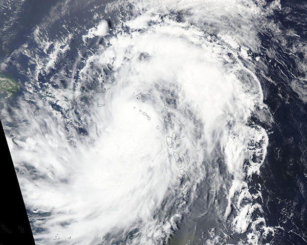
The fifth named storm of the 2024 Atlantic hurricane season was strengthening over the Caribbean on August 13, when the Moderate Resolution Imaging Spectroradiometer (MODIS) on NASA’s Aqua satellite acquired this true color image of Tropical Storm Ernesto.
Near the time the image was captured Ernesto was at tropical storm strength with maximum sustained winds of about 60 miles per hour (96.5 km/h). The center of the large storm was west of St. Kitts and Nevis, with rain bands reaching far over the Leeward Islands. A tropical storm warning was in effect for St. Kitts & Nevis, Montserrat, Antigua & Barbuda, Anguilla, Guadeloupe, St. Martin, St. Barts, British Virgin Islands, US Virgin Islands, and Puerto Rico, according to ReliefWeb.
Ernesto was moving quickly to the northwest, passing over the British Virgin Islands and scooting past eastern Puerto Rico on August 13, constantly strengthening. By August 14, Ernesto had become a Category 1 Hurricane as winds reached 75 miles per hour (121 km/h). It continued to strengthen through the day, making a slow northward turn to travel in the direction of Bermuda, which it is expected to approach late on August 16 or early on August 17.
Even as a tropical storm, Ernesto left substantial damage in its wake, primarily in the form of rain, flooding, downed trees, and widespread power outages. On August 14, the governor of Puerto Rico reported that more than 700,000 customers were without power and 23 hospitals were relying on generators. Island-wide power outages have been reported from St. Croix, where the Estate Richmond Power Plant was impacted, as well as St. John and St. Thomas. Power had been restored to most customers on those islands by August 15.
At 11:00 p.m. EDT on August 15, the National Hurricane Center (NHC) reported that Hurricane Ernesto had reached Category 2 strength as it continued to approach Bermuda and advised that all preparations on Bermuda should be completed before the afternoon of August 16.
At that time, Ernesto was carrying maximum sustained winds of 100 mph (155 km/h), with hurricane-force winds extending 60 miles (95 km) from center and tropical-storm-force winds extending up to 265 miles (425 km) from center. The storm was located about 410 miles (660 km) south-southwest of Bermuda and it was moving north-northeast at 14 miles per hour (22 km/h).
Hurricane Ernesto is moving over warm waters and facing low wind shear. The NHC advised that the storm is continuing to strengthen and could be at major hurricane strength (Category 3) on August 16. It will be a large, powerful hurricane as it passes very close to Bermuda on August 17.
Image Facts
Satellite:
Terra
Date Acquired: 8/13/2024
Resolutions:
1km (304.3 KB), 500m (955.2 KB), 250m (2.6 MB)
Bands Used: 1,4,3
Image Credit:
MODIS Land Rapid Response Team, NASA GSFC
