|
|
|

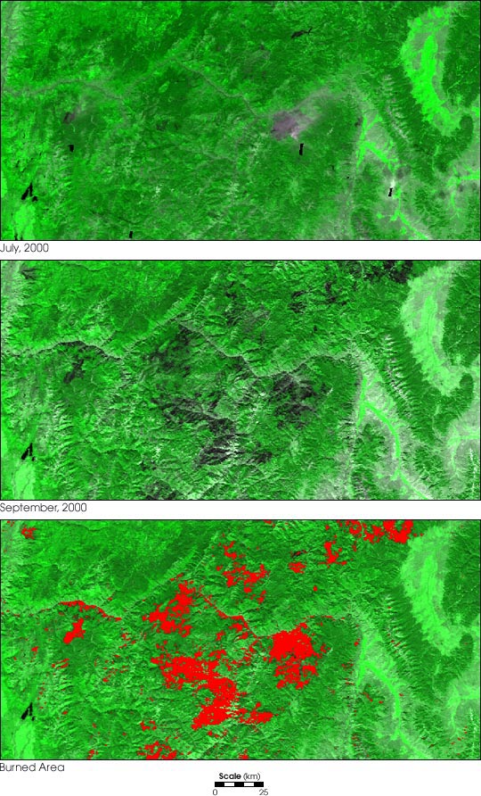
In the aftermath of one of the most devastating
fire seasons in 100 years, the U.S. Forest Service is embarking
on a massive rehabilitation project in the Northern and Intermountain
West. With over 2 million acres burned in Montana and Idaho,
the expected Burned Area Emergency Rehabilitation costs are
close to $20 million dollars for those states alone.
Preliminary assessments of the extent and severity of burned
areas were made through observations from firefighters in
the field and via Forest Service airborne instruments, but
satellite observations such as those acquired by MODIS provide
more comprehensive evaluations of such a large burned area.
The results shown here are based on data acquired by MODIS
in July and September 2000.
 |
| Click this
image for a larger version. |
These images are a demonstration of MODIS’s Vegetative
Cover Conversion (VCC) product, which uses MODIS’ 250-meter
resolution bands to assess changes in the type and amount
of vegetation at locations on the Earth’s surface on
a monthly basis. The 250-m bands detect light in the red and
near-infrared portions of the electromagnetic spectrum. The
VCC product detects change based on two characteristics of
the red and infrared radiation that the Earth reflects onto
MODIS’ detectors: brightness and greenness.
The brightness, or intensity, of radiation reflected from
bare ground is high because there is nothing to absorb it.
A dense forest, on the other hand, absorbs most of the incoming
red radiation, so its brightness is low. The light that a
forest
doesn’t absorb well is infrared, and so heavily vegetated
areas reflect a high proportion of infrared light. The combination
of low red and high infrared reflectance is often referred
to as "greenness."
The VCC product classifies five types of land cover based
on different combinations of brightness and greenness: forest,
non-forest, bare ground, flooding, and burn scar. A forest
is low brightness, high greenness. When the forest is cleared
for agriculture or urban development it shows the high
brightness and low greenness characteristic of bare ground.
So how does the VCC product detect recently burned forested
land, like in these images of the Idaho/Montana border region?
By detecting when a point on the ground goes from low brightness/high
greenness to low brightness/low
greenness, MODIS can tell where dark, partially burned vegetation
has replaced green vegetation.
In these visualizations, the VCC product has identified several
large burn scars, which stand out in deep green against the
brighter green of the remaining forest. The area shown includes
the Clear Creek, Diamond Complex, Wilderness Complex, and
Valley Complex fires. The first image shows the pre-fire landscape
(July 2000); the second image shows the same area after the
fires (September 2000). The final image shows the VCC-detected
change superimposed over the post-fire image. The total burned
area shown in the large images (July
2000, September
2000, Burned
Area) is 3,391 square kilometers.
MODIS’ 250-m resolution VCC product will serve as an
alarm system that warns scientists of possible significant
land cover change. Scientists can then turn to higher-resolution
sensors such as Landat-7, ASTER, or Ikonos for a detailed
look at an area. Other applications of the VCC algorithm include
detection of flooding, urbanization, and logging.
|