
Images


May 18, 2015 - Fires in northern Australia
 Tweet
Tweet
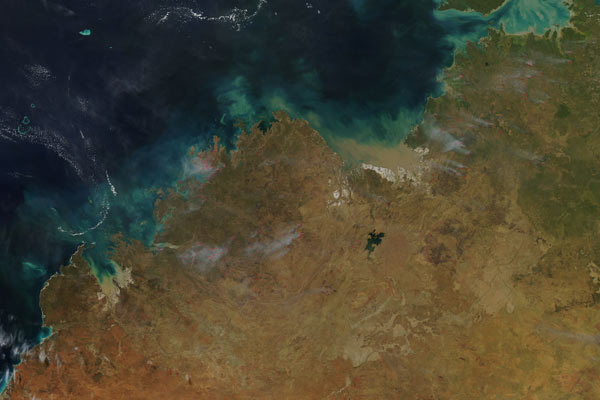
Dozens of fires were burning across northern Australia in early May, 2015. The Moderate Resolution Imaging Spectroradiometer (MODIS) aboard NASA’s Aqua satellite captured this true-color image of fires burning across the region on May 9. Each red “hotspot” marks an area where the thermal sensors on the MODIS instrument detected high temperatures. When combined with typical smoke, as in this image, such hotspots are diagnostic for actively burning fire.
According to the Department of Parks and Wildfire (DPAW) website, several prescribed fires had been set on the Mitchell Plateau in Western Australia, and were burning at the time of this image. The website states that the fires are being set for biodiversity purposes. Some of the positive impacts of prescribed fires are: reduction of hazardous fuels, which protects human communities from extreme fires; minimization of spread of pests and disease; removal of unwanted species; provides forage for game animals; improved habitat for threatened and endangered species; recycles nutrients back to the soil, and promotes the growth of trees, wildflowers and other plants. Forest services around the world manage prescribed fires (also called planned burns) to benefit natural resources and reduce the risk of unwanted wildfires in the future.
While most of the fires in the Western Territory are listed as prescribed burns, many of the fires seen towards the bottom of the image do not correspond to prescribed fires on the DPAW’s website. They may be bushfires – unplanned fires which burn out of control.
Image Facts
Satellite:
Aqua
Date Acquired: 5/9/2015
Resolutions:
1km (296.7 KB), 500m (1 MB), 250m (2.4 MB)
Bands Used: 1,4,3
Image Credit:
Jeff Schmaltz, MODIS Land Rapid Response Team, NASA GSFC
