
Images


August 30, 2015 - Fires and smoke in Washington, Oregon, Idaho, and California
 Tweet
Tweet
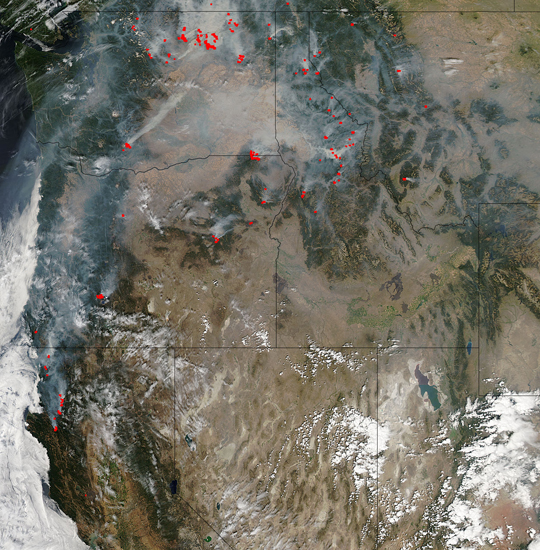
Dozens of red hotspots and abundant gray smoke mark fires burning in the Pacific Northwest and Canada in late August, 2015. The Moderate Resolution Imaging Spectroradiometer (MODIS) aboard NASA’s Aqua satellite captured this true-color image of the on-going fire situation on August 23. The fires cluster most heavily in Washington, with abundant fires also found in Oregon, Idaho and California. Montana also has a sprinkling of fires.
As of August 29 there were 29 active fires listed in the Inciweb database for the state of Washington. The largest active fire listed was the Okanogan Complex Fire which had consumed 302,225 acres and has 1,918 personnel working the fire. This fire began as a lightning strike on August 15 and is only 23% contained. Three U.S. Forest Service firefighters were killed fighting this blaze on August 19. It has become the largest blaze ever reported in the state.
>
As of August 29, there were 40 incidents listed on Inciweb in Idaho. Meanwhile, Oregon has 19 active fires, California reports 39 active fires on that same date. While the image shows only a few fires on August 15, two weeks later the number has risen to 34. A dry winter, spring and summer across the region along with high temperatures, low humidity and strong winds, has created conditions ripe for fire ignition and spread.
Image Facts
Satellite:
Aqua
Date Acquired: 8/23/2015
Resolutions:
1km (672.7 KB), 500m (2.2 MB), 250m (5.3 MB)
Bands Used: 1,4,3
Image Credit:
Jeff Schmaltz, MODIS Land Rapid Response Team, NASA GSFC
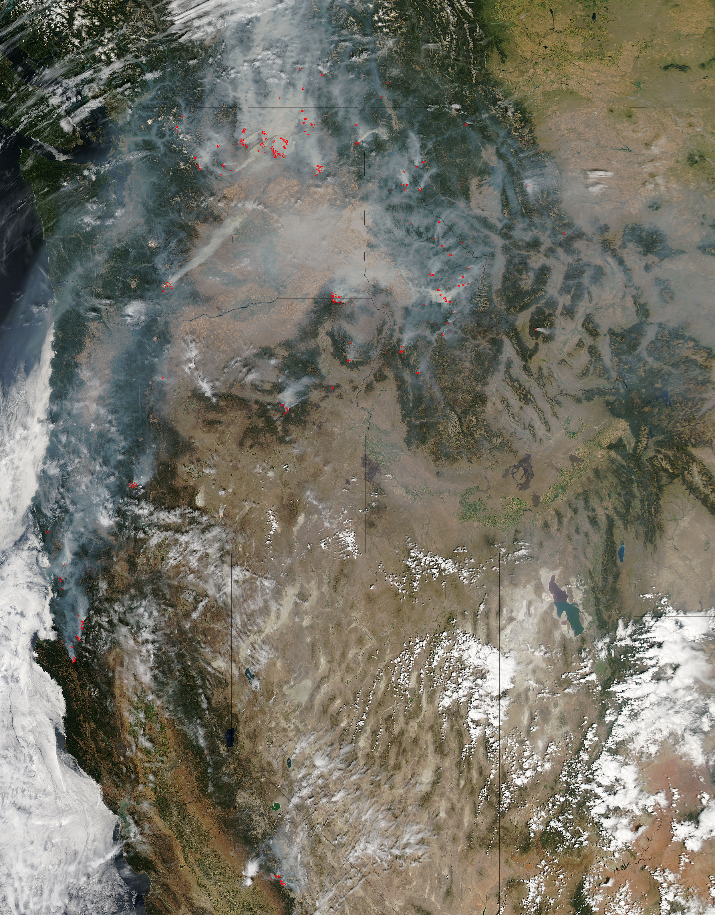
Dozens of red hotspots and abundant gray smoke mark fires burning in the Pacific Northwest and Canada in late August, 2015. The Moderate Resolution Imaging Spectroradiometer (MODIS) aboard NASA’s Aqua satellite captured this true-color image of the on-going fire situation on August 23. The fires cluster most heavily in Washington, with abundant fires also found in Oregon, Idaho and California. Montana also has a sprinkling of fires.
As of August 29 there were 29 active fires listed in the Inciweb database for the state of Washington. The largest active fire listed was the Okanogan Complex Fire which had consumed 302,225 acres and has 1,918 personnel working the fire. This fire began as a lightning strike on August 15 and is only 23% contained. Three U.S. Forest Service firefighters were killed fighting this blaze on August 19. It has become the largest blaze ever reported in the state.
> As of August 29, there were 40 incidents listed on Inciweb in Idaho. Meanwhile, Oregon has 19 active fires, California reports 39 active fires on that same date. While the image shows only a few fires on August 15, two weeks later the number has risen to 34. A dry winter, spring and summer across the region along with high temperatures, low humidity and strong winds, has created conditions ripe for fire ignition and spread.
Image Facts
Satellite:
Aqua
Date Acquired: 8/23/2015
Resolutions:
1km (672.7 KB), 500m (2.2 MB), 250m (5.3 MB)
Bands Used: 1,4,3
Image Credit:
Jeff Schmaltz, MODIS Land Rapid Response Team, NASA GSFC
