Images
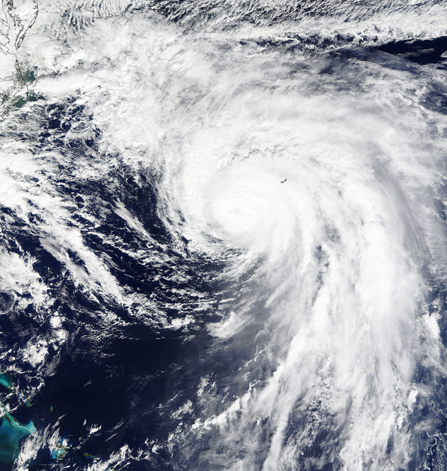
October 7, 2015 - Hurricane Joaquin (11L) over Bermuda
Tweet
On September 27, 2015 the National Hurricane Center (NHC) published the first advisory on Tropical Depression Eleven, noting that a “new tropical depression forms in the western Atlantic”. It was noted that the depression was located about 405 miles (650 km) southwest of Bermuda and was moving to the northwest – potentially putting in a crash course for the east coast of the United States, should it strengthen.
And strengthen it did as it veered away from the United States to threaten Bermuda and then move towards open ocean. On September 30, the storm reached hurricane strength and was named Joaquin. By early on October 1, Hurricane Joaquin became a major hurricane, with maximum sustained winds of 115 mph (185 km/h). The wind speed landed the storm well into the Category 3 status of the Saffir-Simpson Hurricane Wind Scale. By mid-day on October 3, Hurricane Joaquin was pulling away from the Bahamas and heading towards Bermuda – and had reached its peak strength with maximum sustained winds reported at 155 mph (250 km/h), or a very strong Category 4 storm.
On Oct. 4, 2015 at 15:20 UTC (11:20 a.m.) the Moderate Resolution Imaging Spectroradiometer aboard NASA's Terra satellite captured this true-color image of Hurricane Joaquin that showed the northeastern quadrant of the storm was over Bermuda. The eye was still visible in the Terra image, although somewhat obscured by clouds.
At 11 a.m. EDT on October 5, a Tropical Storm Warning was in effect for Bermuda. At that time, the center of Hurricane Joaquin was located near latitude 35.0 North and longitude 64.6 West. That's about 185 miles (300 km) north of Bermuda. Joaquin was moving toward the north-northeast near 13 mph (20 kph), and the National Hurricane Center expect3e a turn toward the northeast followed by a turn toward the east-northeast on Tuesday.
As of late in the day on October 6, Joaquin was still a hurricane as it travelled towards the northeast over open ocean and tracking towards cooler water temperatures and more robust wind shear. According to the NHC bulletin issued at 2100 UTC (5 pm EDT) on October 6, Hurricane Joaquin was racing east northeastward towards cooler waters. It was located at 39.0 North and 56.9 W or about 565 mi (910 km) south-southwest of Cape Race Newfoundland. Maximum sustained winds were about 80 mph (130 km/h) with higher gusts, and continued weakening was expected over the next 48 hours. Joaquin is expected to lose tropical characteristics in about 24 hours and then become a strong extratropical cyclone. No additional hazards to land are currently forecast.
Image Facts
Satellite:
Terra
Date Acquired: 10/4/2015
Resolutions:
1km (1.3 MB), 500m (4.2 MB), 250m (9.8 MB)
Bands Used: 1,4,3
Image Credit:
Jeff Schmaltz, MODIS Land Rapid Response Team, NASA GSFC


