Images
October 9, 2015 - Typhoon Mujigae (22W) approaching China
Tweet
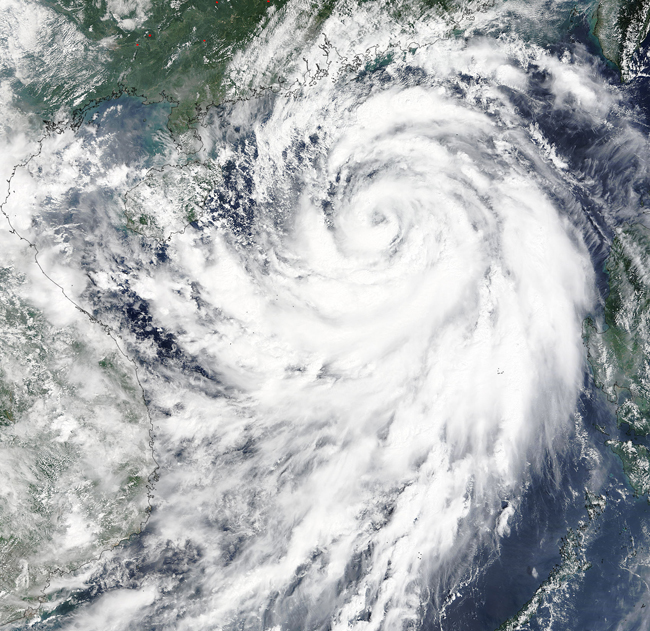
On October 3, 2015, the Moderate Resolution Imaging Spectroradiometer (MODIS) aboard NASA’s Terra satellite captured this true-color image of a strengthening Typhoon Mujigae approaching China.
The storm formed from a tropical depression near Palau and strengthened to tropical storm status on October 1. The Philippine Atmospheric, Geophysical, and Astronomical Services Administration (PAGASA) named the storm Kabayan, while the Joint Typhoon Warning Center (JTWC) first named it 22W then christened it Mujigae as the storm continued to strengthen.
By October 3, Mujigae reached Typhoon strength, with winds of 92 mph (148 km/h), making it a strong Category 1 storm on the Saffir-Simpson Hurricane Wind Scale. As seen in this image, deep convective bands were wrapping tightly into a distinct central eye. The storm was located about 201 mi (323.5 km) south-southwest of Hong Kong, moving northwestward./p>
Typhoon Mujigae reached peak strength on October 4, with winds as high as 134 mph (216 km/h) just before making landfall in Guangdong Province that same day. Once over land, it quickly weakened. The storm was dissipating on October 5 – but not before bringing heavy rainfall and touching off several tornadoes in southern China. The death toll is reported at 20 in China, with damage to over 700 homes.
Image Facts
Satellite:
Terra
Date Acquired: 10/3/2015
Resolutions:
1km (1 MB), 500m (3.2 MB), 250m (7.5 MB)
Bands Used: 1,4,3
Image Credit:
Jeff Schmaltz, MODIS Land Rapid Response Team, NASA GSFC


