
Images


November 18, 2015 - Hurricane Kate (12L) in the North Atlantic Ocean
 Tweet
Tweet
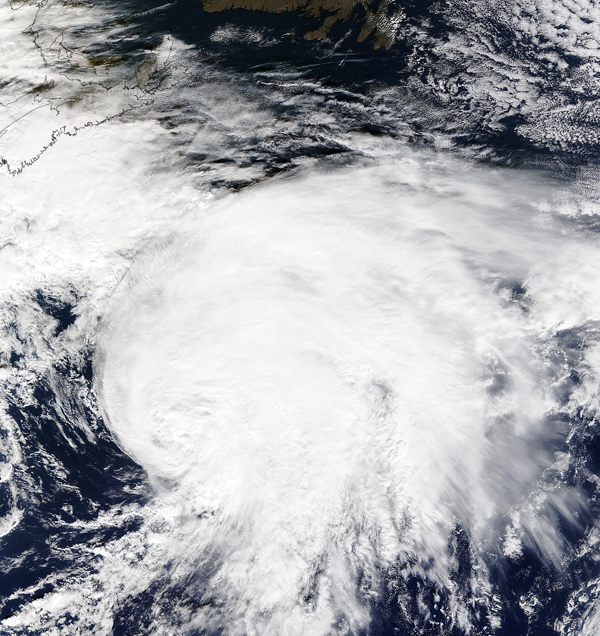
Tropical Depression 12 formed in the Caribbean Sea on November 8, 2015, and became Tropical Storm Kate the next day. After passing within 15 miles of Cat Island, Bahamas Kate tracked northward, staying away from land. On November 11 the storm reached hurricane strength to become the fourth hurricane of the Atlantic season but by November 12 the short-lived Kate had become an extra-tropical cycle and the National Hurricane Center (NHC) issued its last advisory on the system. Remnants of Kate brought wet weather to the United Kingdom on November 14.
According to The Weather Channel, Kate was the latest-in-season tropical cyclone to become a hurricane so far northwest in the Atlantic Ocean on record and the latest-forming Atlantic basin hurricane in 10 years.
The Moderate Resolution Imaging Spectroradiometer (MODIS) aboard NASA’s Terra satellite captured this true-color image of Hurricane Kate as it spun in the North Atlantic Ocean on November 11.
Image Facts
Satellite:
Terra
Date Acquired: 11/11/2015
Resolutions:
1km (1.1 MB), 500m (3.6 MB), 250m (8.6 MB)
Bands Used: 1,4,3
Image Credit:
Jeff Schmaltz, MODIS Land Rapid Response Team, NASA GSFC
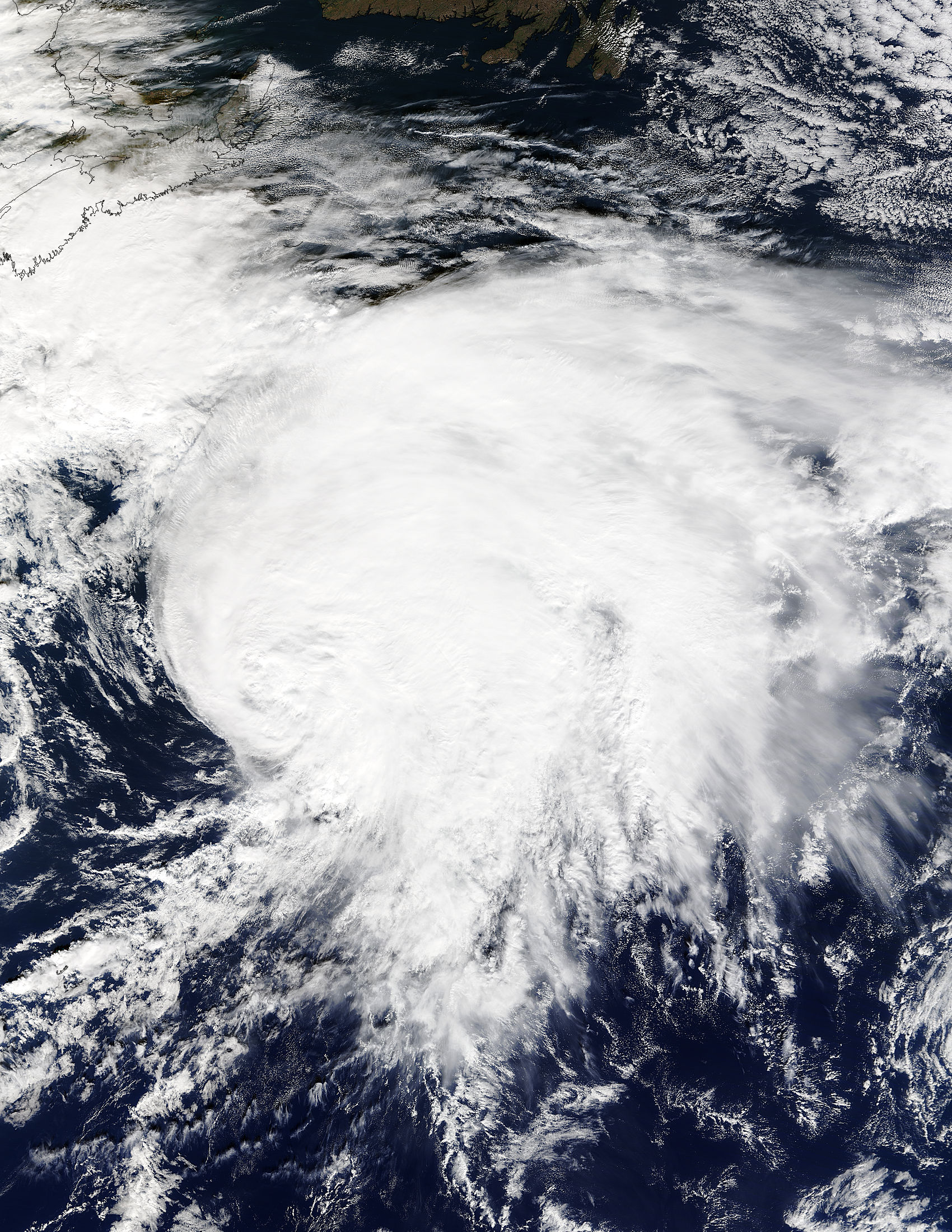
Tropical Depression 12 formed in the Caribbean Sea on November 8, 2015, and became Tropical Storm Kate the next day. After passing within 15 miles of Cat Island, Bahamas Kate tracked northward, staying away from land. On November 11 the storm reached hurricane strength to become the fourth hurricane of the Atlantic season but by November 12 the short-lived Kate had become an extra-tropical cycle and the National Hurricane Center (NHC) issued its last advisory on the system. Remnants of Kate brought wet weather to the United Kingdom on November 14.
According to The Weather Channel, Kate was the latest-in-season tropical cyclone to become a hurricane so far northwest in the Atlantic Ocean on record and the latest-forming Atlantic basin hurricane in 10 years.The Moderate Resolution Imaging Spectroradiometer (MODIS) aboard NASA’s Terra satellite captured this true-color image of Hurricane Kate as it spun in the North Atlantic Ocean on November 11.
Image Facts
Satellite:
Terra
Date Acquired: 11/11/2015
Resolutions:
1km (1.1 MB), 500m (3.6 MB), 250m (8.6 MB)
Bands Used: 1,4,3
Image Credit:
Jeff Schmaltz, MODIS Land Rapid Response Team, NASA GSFC
