
Images


May 30, 2016 - Dust storm in western India
 Tweet
Tweet
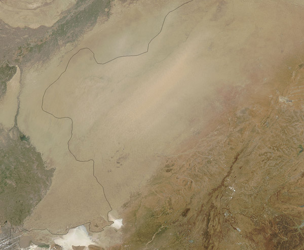
After a spell of blistering heat in late May 2016, heavy storms moved across northern and western India, dropping temperatures but bringing damaging winds that kicked up blinding dust across the region. One of the most fierce storms hit Uttar Pradesh late on May 23, when the skies darkened with dust before strong winds toppled trees and cut power lines as torrential rain began to fall.
The Moderate Resolution Imaging Spectroradiometer (MODIS) aboard NASA's Aqua satellite captured this true-color image on May 26. Another blast of early monsoonal winds carries heavy dust across the state of Rajasthan in western India. The dust, which likely rose from the Thar Desert, is so thick that it obscures the ground from view.
Early on May 29, the Times of India reported that the dust storms and rains will give way during the upcoming week, and Rajasthan will return to heat wave conditions. The city of Jaipur, which had reached 46.8 ˚C (116.24 ˚F) two weeks ago, had cooled to 30.5˚C (86.9˚F) after the stormy weather. The forecast, however, is for summer-like, hot conditions to return in the near term. The monsoon season, bringing rains and relief from heat, typically starts in late May to June.
Image Facts
Satellite:
Aqua
Date Acquired: 5/26/2016
Resolutions:
1km (152.2 KB), 500m (553.6 KB), 250m (1.3 MB)
Bands Used: 1,4,3
Image Credit:
Jeff Schmaltz, MODIS Land Rapid Response Team, NASA GSFC
