
Images


June 28, 2016 - Southcentral Alaska
 Tweet
Tweet
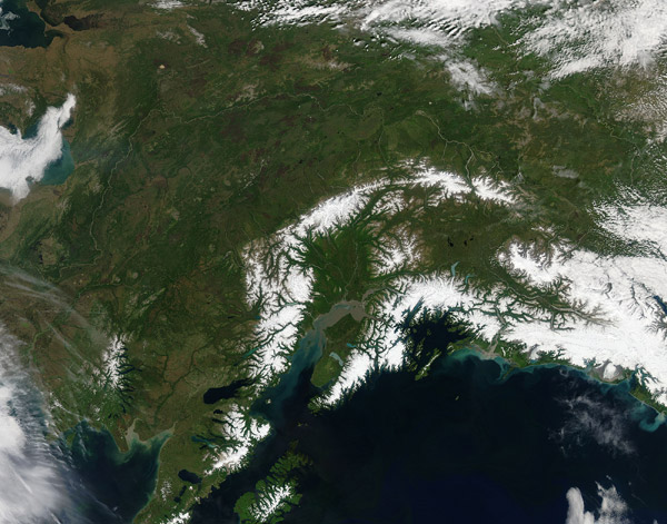
Snow blanketed the mountain peaks in South Central Alaska as smoke colored the skies to the west in mid-June 2016. The Moderate Resolution Imaging Spectroradiometer (MODIS) aboard NASA's Aqua satellite captured this true-color image on June 15.
The largest mountain range is the Alaska Range, home to Denali National Park. Starting at Alaska's eastern border with Canada, the Alaska Range arcs across the north of South Central Alaska before ending to the west of the rugged Kenai Peninsula. The arc of mountains close to the coast is made up of the Chugach Mountains in the east and the Kenai Mountains in the west. On the coast, the Cook Inlet is filled with brownish sediment. Anchorage, Alaska's most populous city, sits at the terminus of the Cook Inlet.
Thanks to a warm winter and an early, warm spring, fire risk in high across Alaska. While most of the South Central Region has been spared, fires have been abundant across the state, particularly in the north central region. Summer storms and accompanying active lightning have ignited multiple fires. On June 26, the Alaska Wildland Fire website reported that 10,292 lightning strikes were recorded between 6 a.m. and 6 p.m. on that date, resulting in at least 37 new fires.
Image Facts
Satellite:
Aqua
Date Acquired: 6/15/2016
Resolutions:
1km (481.9 KB), 500m (1.7 MB), 250m (4.1 MB)
Bands Used: 1,4,3
Image Credit:
Jeff Schmaltz, MODIS Land Rapid Response Team, NASA GSFC
