
Images


July 2, 2016 - Erskine Fire, California
 Tweet
Tweet
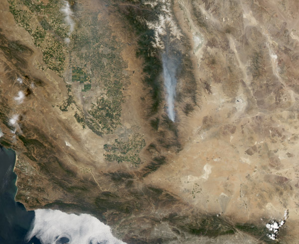
A wildfire burning northeast of Bakersfield, California, is the state's largest so far in 2016, according to news reports. It has also been called the season's a most destructive fire. As of July 1, the Erskine fire had scorched about 19,370 hectares (47,864 acres), destroyed at least 250 structures, and was responsible for at least two deaths.
The Moderate Resolution Spectroradiometer (MODIS) aboard NASA's Aqua satellite acquired this true-color image of the Erskine Fire on June 26. Red outlines indicate hot spots where MODIS detected warm surface temperatures associated with fires. Winds carried smoke from the fire northward.
The fire first ignited on June 23 due to a yet-unknown cause. On the date these images were acquired, the fire had burned 17,588 hectares (43,460 acres). As of July 1, the fire perimeter was 80 percent contained and 909 personnel continued to fight the fire.
According to the National Interagency Fire Center, above- normal fire potential is expected to expand into the Sierras and central coast region of California as summer progresses. According to the outlook: "The highest potential may be over the Sierra Foothills where a severe, multiyear drought has exacted a toll on the vegetation of the area."
Image Facts
Satellite:
Aqua
Date Acquired: 6/26/2016
Resolutions:
1km (111.5 KB), 500m (325.4 KB), 250m (752.1 KB)
Bands Used: 1,4,3
Image Credit:
Jeff Schmaltz, MODIS Land Rapid Response Team, NASA GSFC
