Images
May 25, 2018 - Wildfires in Canada
Tweet
Hot, dry weather moved across Canada in May 2018, creating extreme fire conditions in parts of Manitoba and Saskatchewan. An ‘extreme’ status means fires could be fast-spreading, high-intensity and very difficult to control.
According to a story run by the Canadian Press on May 16, Manitoba had counted 119 fires so far, which is well above average. The report stated that by this time last year (2017) the number of fires was 27, and in 2016 there had been 58 fires by the same date. Two sets of evacuations have occurred near Crutwell, Saskatchewan and one in Lac du Bonnet, Manitoba.
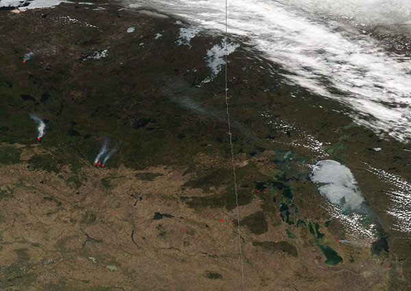
On May 20, 2018, the Moderate Resolution Imaging Spectroradiometer (MODIS) aboard NASA’s Aqua satellite acquired a true-color image of fires burning in Canada.
Each red dot marks a hot spot – an area where the thermal bands on the instrumented detected high temperatures. When accompanied by typical smoke, as in this image, such hot spots are diagnostic for actively burning fires. Large fires in the west burn in forested areas of Saskatchewan. In the east a cluster of fires burn near Lake Winnipegosis, Manitoba.
Image Facts
Satellite:
Date Acquired: 5/20/2018
Resolutions:
Bands Used:
Image Credit:
Jeff Schmaltz, MODIS Land Rapid Response Team, NASA GSFC
Tweet
Hot, dry weather moved across Canada in May 2018, creating extreme fire conditions in parts of Manitoba and Saskatchewan. An ‘extreme’ status means fires could be fast-spreading, high-intensity and very difficult to control.
According to a story run by the Canadian Press on May 16, Manitoba had counted 119 fires so far, which is well above average. The report stated that by this time last year (2017) the number of fires was 27, and in 2016 there had been 58 fires by the same date. Two sets of evacuations have occurred near Crutwell, Saskatchewan and one in Lac du Bonnet, Manitoba.
On May 20, 2018, the Moderate Resolution Imaging Spectroradiometer (MODIS) aboard NASA’s Aqua satellite acquired a true-color image of fires burning in Canada. Each red dot marks a hot spot – an area where the thermal bands on the instrumented detected high temperatures. When accompanied by typical smoke, as in this image, such hot spots are diagnostic for actively burning fires. Large fires in the west burn in forested areas of Saskatchewan. In the east a cluster of fires burn near Lake Winnipegosis, Manitoba.
Image Facts
Satellite:
Date Acquired: 5/20/2018
Resolutions:
Bands Used:
Image Credit:
Jeff Schmaltz, MODIS Land Rapid Response Team, NASA GSFC


