
Images


July 17, 2019 - Fires in Northern Territory, Australia
 Tweet
Tweet
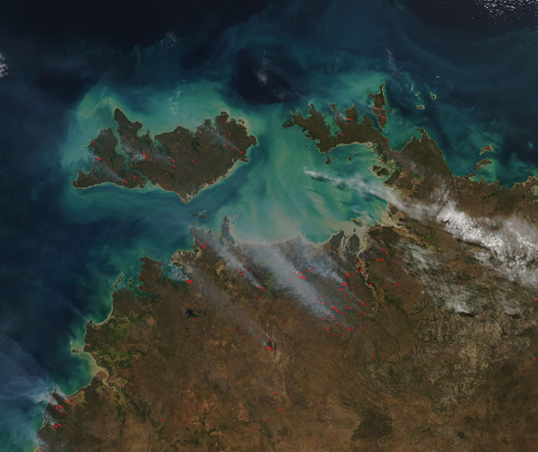
Many dozens of fires poured smoke into the skies over Australia’s Northern Territory through mid-July 2019. The Moderate Resolution Imaging Spectroradiometer (MODIS) on board NASA’s Aqua satellite acquired a true-color image of the fiery scene on July 15.
The Australian Bureau of Meteorology (BoM) reported that the rainfall for the 2018-2019 wet season for most of the Northern Territory was well below average, with many locations reporting the lowest total rainfall on record, or the lowest total for at least 25 years. At the same time, the wet season, which runs from October 2018 to April 2019, was the hottest on record, with maximum, minimum, and mean temperatures all the highest since record-keeping began in 1910. The longest run of hot temperatures were set at Rabbit Flat, in south-central Northern Territory, with a run of 115 days of at least 39°C (102.2°F).
While the searing heat was worst in the center and south of the Northern Territory, the Top End was not spared, with the conditions causing normally-green vegetation to become tinder-dry. As a result, any spark runs the risk of igniting a fast-growing fire, especially when winds are strong.
Due to extreme fire weather, the Chief Fire Control Officer, Bushfires NT, and the Executive Director, Northern Territory Fire and Rescue Service have declared fire bans for July 14 and July 15 for the Darwin and Adelaide River Fire Weather Forecast Areas. No person is permitted to light a fire or cause a fire to be lit in the open portion of the territory within the fire ban areas.
Image Facts
Satellite:
Aqua
Date Acquired: 7/15/2019
Resolutions:
1km (174.5 KB), 500m (441.5 KB), 250m (838.7 KB)
Bands Used:
Image Credit:
MODIS Land Rapid Response Team, NASA GSFC
