
Images


November 8, 2019 - Snow in the Rockies
 Tweet
Tweet
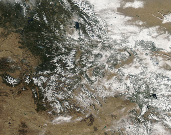
The Northern Rockies are no stranger to early snow, but the winter of 2019-2020 rocketed off to an exceptional start, with three separate large snowstorms before the close of October. The Moderate Resolution Imaging Spectroradiometer (MODIS) on board NASA’s Aqua satellite acquired a true-color image of snow across the Rocky Mountains of Idaho, Montana, and Wyoming on November 1, 2019.
While the blanket of snow as seen from space appears impressive, the statistics help drive home the exceptional nature of the early precipitation. According to the Weather Channel, “Great Falls, Montana, picked up 36.5 inches of snow so far this season. This was easily their record snowiest start to the season through Nov. 4, over a foot snowier than fall 1925 to date (22.8 inches)”.
Heavy snow doesn’t just make for an early ski season. Many of the Rocky Mountain States depend on substantial snowpack accumulation in the winter to supply reservoirs with water for residential, industrial and agricultural use. Low snowpack over several recent years has helped fuel drought conditions in parts of the Western United States. Fortunately, the winter of 2018-2019 ended with above-average snowpack in some areas, bringing some relief.
Image Facts
Satellite:
Aqua
Date Acquired: 11/1/2019
Resolutions:
1km (752.8 KB), 500m (2.1 MB), 250m (4.3 MB)
Bands Used: 1,4,3
Image Credit:
MODIS Land Rapid Response Team, NASA GSFC
