
Images


January 18, 2020 - Water in the Cuvelai-Etosha Basin
 Tweet
Tweet
Encompassing about five percent of Namibia, the Cuvelai-Etosha Basin is home to almost half of the country's population. In the dry season, water begins to evaporate, leaving behind crusts of salt on many of the small, seasonal lakes in the region. The largest, Etosha Pan, measures about 75 miles (120 km) in length but is very shallow. Most of the year the crusted lakebed contains very little water and is so dry that winds blowing across it can pick up saline dust, carrying it across the country and out over the southern Atlantic Ocean. The salt enrichment provides minerals to the soil downwind of the pan, but the salinity in the region creates challenges to agriculture nearby.
Although the region is extremely dry most of the year, the drainage system of the Cuvelai-Etosha Basin contains hundreds of small streams and channels that come from the highlands of Angola and lead to a network of shallow lakes. As rains come to the highlands, these channels and streams flow with fresh water, filling the lakes to the brim—and usually beyond. Sporadic widespread floods, called “efundja” bring challenges to the people living in the region, often bringing water into their homes. But they also bring the joys of fresh water and the ability to catch fish. Within weeks of the start of efundja, huge numbers of fish appear, seemingly from nowhere, bringing delicious and abundant protein for the population. As the Etosha Pan becomes covered with fresh water, it draws an abundance of game animals and birds, including flamingo. By April, the water has withdrawn, the fish, the birds, and most of the large mammals have disappeared and Etosha Pan once again wears a thick crust of salt and minerals.
Starting in late December, 2019, rains began to fall in the region. By January 8, the Namibian Broadcasting Company (NBC), reported that the Cuvelai-Etosha Basin had received extremely good rains in recent weeks. They also stated that there was no flooding.
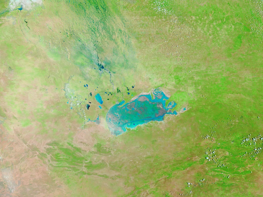
The Moderate Resolution Imaging Spectroradiometer (MODIS) on board NASA’s Terra satellite acquired a false-color image of water filling the Cuvelai-Etosha Basin on January 17, 2020. In this band combination, which uses visible and near-infrared light, vegetation appears bright green and water appears electric blue. The Etosha Pan has partially filled with water while many of the lakes and streams appear quite full.
To view a stunning roll-over comparison of the water levels on December 12, 2019 and on January 17, 2020, click HERE.
The comparison is provided by Worldview. The NASA Worldview app provides a satellite's perspective of the planet as it looks today and as it has in the past through daily satellite images. Worldview is part of NASA’s Earth Observing System Data and Information System. EOSDIS makes the agency's large repository of data accessible and freely available to the public.
Image Facts
Satellite:
Terra
Date Acquired: 1/17/2020
Resolutions:
1km (177.3 KB), 500m (468.1 KB), 250m (978.9 KB)
Bands Used: 1,4,3
Image Credit:
MODIS Land Rapid Response Team, NASA GSFC
Encompassing about five percent of Namibia, the Cuvelai-Etosha Basin is home to almost half of the country's population. In the dry season, water begins to evaporate, leaving behind crusts of salt on many of the small, seasonal lakes in the region. The largest, Etosha Pan, measures about 75 miles (120 km) in length but is very shallow. Most of the year the crusted lakebed contains very little water and is so dry that winds blowing across it can pick up saline dust, carrying it across the country and out over the southern Atlantic Ocean. The salt enrichment provides minerals to the soil downwind of the pan, but the salinity in the region creates challenges to agriculture nearby.
Although the region is extremely dry most of the year, the drainage system of the Cuvelai-Etosha Basin contains hundreds of small streams and channels that come from the highlands of Angola and lead to a network of shallow lakes. As rains come to the highlands, these channels and streams flow with fresh water, filling the lakes to the brim—and usually beyond. Sporadic widespread floods, called “efundja” bring challenges to the people living in the region, often bringing water into their homes. But they also bring the joys of fresh water and the ability to catch fish. Within weeks of the start of efundja, huge numbers of fish appear, seemingly from nowhere, bringing delicious and abundant protein for the population. As the Etosha Pan becomes covered with fresh water, it draws an abundance of game animals and birds, including flamingo. By April, the water has withdrawn, the fish, the birds, and most of the large mammals have disappeared and Etosha Pan once again wears a thick crust of salt and minerals.
Starting in late December, 2019, rains began to fall in the region. By January 8, the Namibian Broadcasting Company (NBC), reported that the Cuvelai-Etosha Basin had received extremely good rains in recent weeks. They also stated that there was no flooding.
The Moderate Resolution Imaging Spectroradiometer (MODIS) on board NASA’s Terra satellite acquired a false-color image of water filling the Cuvelai-Etosha Basin on January 17, 2020. In this band combination, which uses visible and near-infrared light, vegetation appears bright green and water appears electric blue. The Etosha Pan has partially filled with water while many of the lakes and streams appear quite full.
To view a stunning roll-over comparison of the water levels on December 12, 2019 and on January 17, 2020, click HERE.
The comparison is provided by Worldview. The NASA Worldview app provides a satellite's perspective of the planet as it looks today and as it has in the past through daily satellite images. Worldview is part of NASA’s Earth Observing System Data and Information System. EOSDIS makes the agency's large repository of data accessible and freely available to the public.
Image Facts
Satellite:
Terra
Date Acquired: 1/17/2020
Resolutions:
1km (177.3 KB), 500m (468.1 KB), 250m (978.9 KB)
Bands Used: 1,4,3
Image Credit:
MODIS Land Rapid Response Team, NASA GSFC
