
Images


March 31, 2020 - Ice in the Missouri River
 Tweet
Tweet
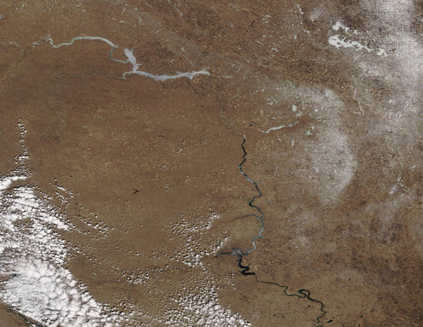
Thanks to a relatively warm autumn and gentle winter in North Dakota, the annual ice-up of much of the Missouri River came slowly this year. The large Lake Sakakawea, covering 180 miles behind the Garrison Dam on the Missouri River, finally was declared frozen by the U.S. Army Corps of Engineers on January 11, 2020. Although a late date, that date does fall within the long-term norm for ice-up, according to local news reports.
On March 29, 2020, when the Moderate Resolution Imaging Spectroradiometer (MODIS) on board NASA’s Terra satellite flew over North Dakota and acquired a true-color image of ice lingering on the upper Missouri River.
The river’s course shows blue, open water from South Dakota (near the bottom edge of the image) almost all the way to Lake Sakakawea in North Dakota. The frozen waters appear bright white. Several tributaries to the Missouri River also appear white. In the northeast, Devil’s Lake, a prime ice-fishing location, also appears covered in ice. Fishing reports for that lake, however, suggest that the ice has begun to melt, creating soft ice in spots that can appear solid, but is deceptively dangerous.
According to a story published in mid-January by the Minot Daily News, “the earliest ice-free date on record for Lake Sakakawea is March 27, 2018. Generally though, mid-April is when the reservoir can be expected to become free of ice. However, there have been many years when Lake Sakakawea was not ice free until the month of May. The latest ice free date for Sakakawea is May 17, 1979.” Lake Sakakawea was impounded by the completion of Garrison Dam in 1956.
Image Facts
Satellite:
Terra
Date Acquired: 3/29/2020
Resolutions:
1km (186.8 KB), 500m (517 KB), 250m (1.1 MB)
Bands Used: 1,4,3
Image Credit:
MODIS Land Rapid Response Team, NASA GSFC
