
Images


August 5, 2020 - Hurricane Isaias
 Tweet
Tweet
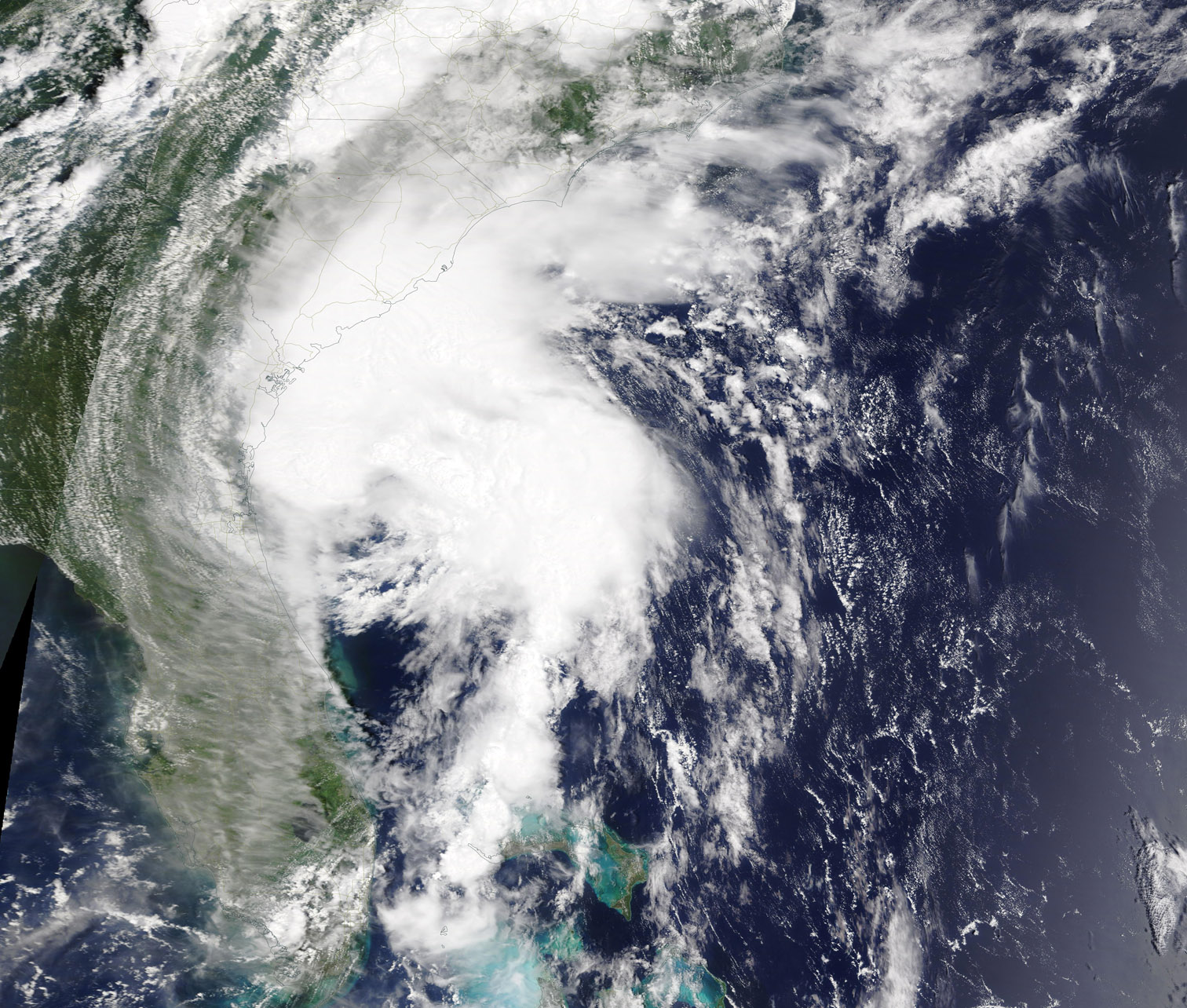
Hurricane Isaias was approaching North Carolina on the afternoon of August 3, 2020 when the Moderate Resolution Imaging Spectroradiometer (MODIS) on board NASA’s Terra satellite acquired a true-color image of the storm.
The eye made landfall near Ocean Isle Beach in southern North Carolina around 11:10 p.m. EDT (0310 UTC) on August 3, less than ten hours after this image was acquired. It was packing maximum sustained winds of 85 mph (140 km/h) as it reached shore, making it a Category 1 hurricane on the Saffir-Simpson Hurricane Wind Scale. A weather station at Oak Island, North Carolina reported gusts as high as 87 mph (140 km/h) while one located in Federal Point, North Carolina, reported 99 mph (159 km/h) gusts.
Shortly after coming ashore, Hurricane Isaias began to weaken as it moved rapidly up the East Coast of the United States, leaving a trail of floods and wind damage from North Carolina to New York. Traveling roughly along the busy I-95 corridor, Isaias spawned a number of tornadoes in the south-east quadrant. A tornado touched down in Bertie County, North Carolina shortly after landfall, killing two people with two more people missing. Residents of southern and eastern Maryland were woken early on August 4 by a number of tornado warnings registering almost simultaneously from St. Mary’s to Cecil County. As of 11:00 p.m. EDT (0300 UTC) on August 4, the National Weather Service has confirmed three tornadoes had touched down in Maryland and one in Delaware, all spawned by Isaias as the storm passed at tropical storm strength. Strong winds, heavy flooding, and downed trees have been reported from North Carolina through New York on August 4. More than 3.4 million homes are reported to be without power.
Prior to its run up the East Coast, Isaias formed from a depression on July 29 about 150 miles (241 km) south of Puerto Rico. It left a trail of heavy rain, flooding, and wind damage across Puerto Rico and Hispaniola before lashing the Bahamas on August 1 and 2. Tropical Storm Isaias threatened Florida and Georgia, but stayed offshore, from August 2 to 3 before turning it’s attention to North Carolina.
Environment Canada’s Hurricane Center has predicted that the post-tropical cyclone would reach Quebec City on August 5th then travel northeast to Labrador by August 6. Although much weakened, the storm can still carry substantial rain with potential for flooding.
Image Facts
Satellite:
Terra
Date Acquired: 8/3/2020
Resolutions:
1km (561.2 KB), 500m (1.7 MB), 250m (3.4 MB)
Bands Used: 1,4,3
Image Credit:
MODIS Land Rapid Response Team, NASA GSFC
