
Images


January 13, 2022 - Cloud Streets over the Great Lakes
 Tweet
Tweet
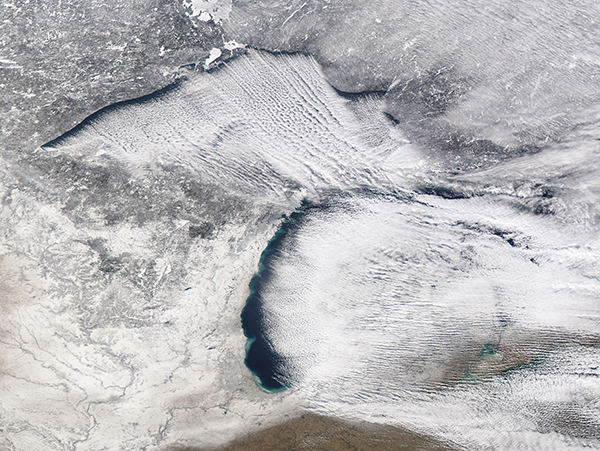
Frigid weather and strong winds collaborated to created spectacular cloud formations over two of the Great Lakes in early January 2022. The Moderate Resolution Imaging Spectroradiometer (MODIS) on board NASA’s Aqua satellite acquired a true-color image of the clouds over Lakes Superior and Michigan on January 10. The long rows of parallel white clouds—called “cloud streets”—are most clearly defined and dramatic over Lake Superior (north), but some also exist over Lake Michigan.
Clouds streets form when frigid, dry air blows across a relatively warmer body of water, such as the Great Lakes. As an air mass blows over cold land, it becomes cold and very dry. As this cold and dry air mass moves over the moist and warmer water of the lakes, it picks up water vapor to form clouds. When the air rises upward in columns (thermals), it carries heat away from the lake surface and becomes chilled as it rises. When this now-moist and chilled air meets a warmer air layer (a temperature inversion), the warmer layer acts like a lid and stops any more upward motion. The inversion causes the rising thermals to roll over on themselves, forming parallel cylinders of rotating air. On the upward side of the cylinders (rising air), water vapor condenses to form clouds. Along the downward side (descending air), skies remain clear.
On January 9-10, a mass of frigid Arctic air blasted across the Great Lakes Region, causing temperatures to drop dramatically. The high temperature on January 10 in Thunder Bay, Ontario, Canada registered only -7˚F (-21˚C), while the low hit -21˚F (-29.4˚C). Thunder Bay sits on the northwestern shore of Lake Superior. On that same day Green Bay, on the western shore of Lake Michigan registered a warmer (but still frigid) high of 5˚F (-15˚C).
Image Facts
Satellite:
Aqua
Date Acquired: 1/20/2022
Resolutions:
1km (1.6 MB), 500m (4.6 MB), 250m (3.6 MB)
Bands Used: 1,4,3
Image Credit:
MODIS Land Rapid Response Team, NASA GSFC
