
Images


January 27, 2022 - Hamun-e Jaz Murian, Iran
 Tweet
Tweet
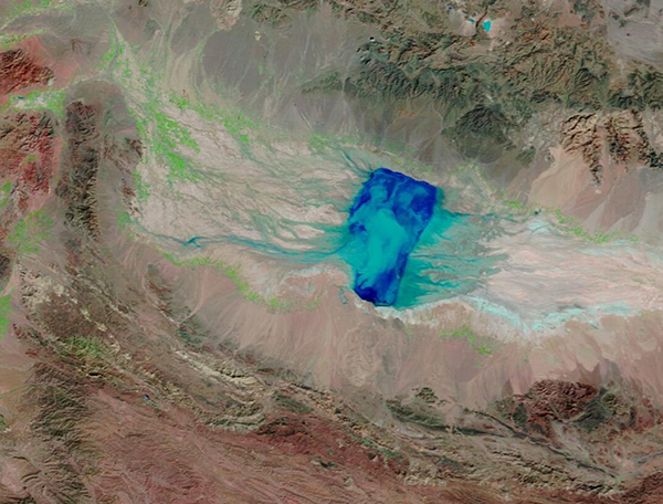
The Hamun-e Jaz Murian basin stretches over about 68,311 square kilometers (26,374 sq. mi) in southeastern Iran. Surrounded by mountains on all sides, most of the arid basin receives less than 100 mm (4 inches) of precipitation each year. The wettest part, in the west, still only receives about 200 mm (8 in) annually. In contrast, annual evaporation across the basin has been estimated at 2,500 mm (98 in), creating a very arid environment that only temporarily retains moisture.
At the lowest elevation, the basin is filled with large alluvial fans, lake sediments, and dunes—and is known as a large source of sand and dust for dust storms that periodically cover the region. The lowest part of the basin also contains a “hamun”—a seasonal desert lake—and marshland. When rains do come to southeastern Iran, water fills two rivers, the Bampur and Halil Rud, which flow into the basin to bring the seasonal lake, Hamun-e Jaz Murian, to life.
Southeastern Iran has been suffering from a long-standing drought. In early January 2022 the skies opened up, bringing heavy snow and rain across the basin and the surrounding mountains. In just the first week of January, destructive floods washed out bridges, swept away cars, swamped homes, and inundated farmland. The floods have killed at least 10 people and damaged hundreds of homes and vehicles.
According to Reliefweb, heavy rainfall has continued to affect central and southern Iran since January 18, triggering floods and causing a number of severe weather-related incidents. The article states that as of January 20, the Iranian Red Crescent Society (IRCS) and media report around 18,000 people and about 1,200 homes have been impacted across more than 300 villages in Kerman Province. Hamun-e Jaz Murian sits in Kerman Province. Local media reported up to six feet of snow in some mountain passes, effectively cutting off access to hundreds of mountain villages. The heavy precipitation has also helped fill Hamun-e Jaz Murian, creating a large lake and spreading marshland.
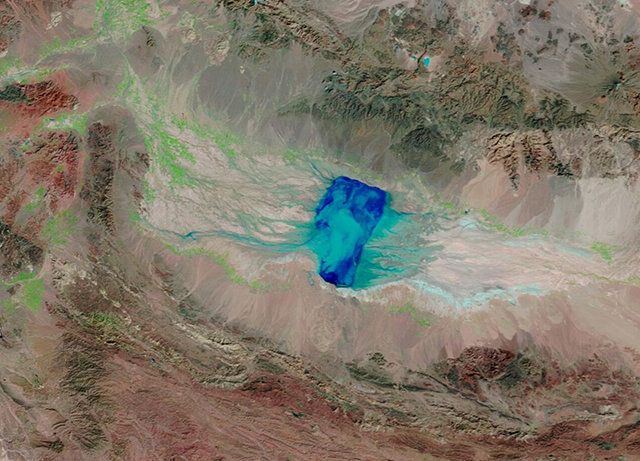
The Moderate Resolution Imaging Spectroradiometer (MODIS) on board NASA’s Terra satellite acquired a false-color image of Hamun-e Jaz Murian filling up with flood waters on January 24, 2022. This type of false color image uses a combination of visible and shortwave infrared light (bands 7-2-1) to make it easier to distinguish between land and water. Dry land appears brown; vegetated areas are green. Areas covered by water are dark blue. Snow appears bright blue and cloud appears either white or, if the clouds contain ice crystals, may contain a light wash of bright blue.
While this single image gives an impressive vision of the state of Hamun-e Jaz Murian at one point in time, and shows substantial flooding, sometimes it is helpful to visualize changes over time. The NASA Worldview App makes it easy to compare MODIS images of the same area acquired on different days. To compare the rise of the flood waters at Hamun-e Jaz Murian between January 14, 2022, and January 24, click
here.
Image Facts
Satellite:
Terra
Date Acquired: 1/24/2022
Resolutions:
1km (300.8 KB), 500m (300.5 KB), 250m (876.3 KB)
Bands Used: 7,2,1
Image Credit:
MODIS Land Rapid Response Team, NASA GSFC
The Hamun-e Jaz Murian basin stretches over about 68,311 square kilometers (26,374 sq. mi) in southeastern Iran. Surrounded by mountains on all sides, most of the arid basin receives less than 100 mm (4 inches) of precipitation each year. The wettest part, in the west, still only receives about 200 mm (8 in) annually. In contrast, annual evaporation across the basin has been estimated at 2,500 mm (98 in), creating a very arid environment that only temporarily retains moisture.
At the lowest elevation, the basin is filled with large alluvial fans, lake sediments, and dunes—and is known as a large source of sand and dust for dust storms that periodically cover the region. The lowest part of the basin also contains a “hamun”—a seasonal desert lake—and marshland. When rains do come to southeastern Iran, water fills two rivers, the Bampur and Halil Rud, which flow into the basin to bring the seasonal lake, Hamun-e Jaz Murian, to life.
Southeastern Iran has been suffering from a long-standing drought. In early January 2022 the skies opened up, bringing heavy snow and rain across the basin and the surrounding mountains. In just the first week of January, destructive floods washed out bridges, swept away cars, swamped homes, and inundated farmland. The floods have killed at least 10 people and damaged hundreds of homes and vehicles.
According to Reliefweb, heavy rainfall has continued to affect central and southern Iran since January 18, triggering floods and causing a number of severe weather-related incidents. The article states that as of January 20, the Iranian Red Crescent Society (IRCS) and media report around 18,000 people and about 1,200 homes have been impacted across more than 300 villages in Kerman Province. Hamun-e Jaz Murian sits in Kerman Province. Local media reported up to six feet of snow in some mountain passes, effectively cutting off access to hundreds of mountain villages. The heavy precipitation has also helped fill Hamun-e Jaz Murian, creating a large lake and spreading marshland.
The Moderate Resolution Imaging Spectroradiometer (MODIS) on board NASA’s Terra satellite acquired a false-color image of Hamun-e Jaz Murian filling up with flood waters on January 24, 2022. This type of false color image uses a combination of visible and shortwave infrared light (bands 7-2-1) to make it easier to distinguish between land and water. Dry land appears brown; vegetated areas are green. Areas covered by water are dark blue. Snow appears bright blue and cloud appears either white or, if the clouds contain ice crystals, may contain a light wash of bright blue.
While this single image gives an impressive vision of the state of Hamun-e Jaz Murian at one point in time, and shows substantial flooding, sometimes it is helpful to visualize changes over time. The NASA Worldview App makes it easy to compare MODIS images of the same area acquired on different days. To compare the rise of the flood waters at Hamun-e Jaz Murian between January 14, 2022, and January 24, click here.
Image Facts
Satellite:
Terra
Date Acquired: 1/24/2022
Resolutions:
1km (300.8 KB), 500m (300.5 KB), 250m (876.3 KB)
Bands Used: 7,2,1
Image Credit:
MODIS Land Rapid Response Team, NASA GSFC
