
Images


November 26, 2022 - Snow Across the Himalayas and Kunlun Mountains
 Tweet
Tweet
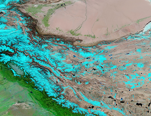
Fresh snow topped the Himalayas and the Kunlun Mountains in late November 2022.
On November 24, the Moderate Resolution Imaging Spectroradiometer (MODIS) on board NASA’s Aqua satellite acquired a false-color image of the tall peaks between China’s Taklamakan Desert (north) and India’s Indo-Gangetic Plain. The use of infrared and visible light (MODIS bands 7,2,1) helps separate snow, which appears bright electric blue, from standing water/lakes, which appear dark blue. Also, vegetation appears bright green while open land looks tan or brown.
The extremely dry and sand-filled Taklamakan Desert fills the northern section of the image. Vegetation flourishes where moisture exists, both around the edges of the desert and along a very few rivers that flow toward the center of the Taklamakan. The topography sharply increases on the southwestern and southern edge of the desert, where the Kunlun Mountains rise upward more than 23,000 feet in some locations. Further south, the tall Himalaya Mountains roughly parallel the Kunlun in the west, but the two ranges diverge in the east, split by the Tibetan Plateau. The Tibetan Plateau is sometimes called the “Roof of the World” as it is the world’s highest and largest plateau, with an average elevation of more than 14,000 feet. Many lakes speckle the Tibetan Plateau. The southern slopes of the Himalayas are covered with deep green vegetation, indicating abundant moisture. The low-lying plain at the foot of the Himalayas is an extremely fertile region, as can be inferred from the abundant vegetation that spreads southward to the edge of the image.
Image Facts
Satellite:
Aqua
Date Acquired: 11/24/2022
Resolutions:
1km (770.4 KB), 500m (6.5 MB), 250m (4.4 MB)
Bands Used: 1,4,3
Image Credit:
MODIS Land Rapid Response Team, NASA GSFC
