
Images


March 26, 2023 - Cloud Streets over the Labrador Sea
 Tweet
Tweet
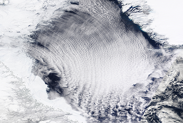
On March 23, 2023, the Moderate Resolution Imaging Spectroradiometer (MODIS) on board NASA’s Terra satellite captured a true-color image of a spectacular cloud formation above the Labrador Sea.
The Labrador Sea is flanked by Canada’s Labrador Peninsula in the southwest and Greenland in the northeast. It is part of the North Atlantic Ocean and connects to the Arctic Ocean via various straits and bays to the north.
Springtime brings big changes to the region, as fast ice—ice which clings to shore—and floating sea ice begin to melt as daylight lengthens. Despite warming air temperature, strong winds often blow from the north, carrying bitterly frigid air. Both the melting ice and frigid air can create beautiful patterns when viewed from space.
In this image, the sheets of fast ice clinging to the Labrador Peninsula are edged with delicate filigrees. These delicate patterns are created by the interaction of thin ice floating over moving currents and waves.
The predominant pattern, however, is the long, parallel bands of white that stretch across the Labrador Sea. Called “cloud streets”, this type of cumulus cloud is common during the spring, when cold, dry air blows over comparatively warmer water. The clouds form at the top of parallel cylinders of rotating air, created by rising warm, moist air. On the upward side of the cylinders (rising air), water vapor condenses and forms clouds. Along the downward side (descending air), skies remain clear. The streets form along the direction of the prevailing wind.
Image Facts
Satellite:
Terra
Date Acquired: 3/23/2023
Resolutions:
1km (2.2 MB), 500m (6.2 MB), 250m (5.4 MB)
Bands Used: 1,4,3
Image Credit:
MODIS Land Rapid Response Team, NASA GSFC
On March 23, 2023, the Moderate Resolution Imaging Spectroradiometer (MODIS) on board NASA’s Terra satellite captured a true-color image of a spectacular cloud formation above the Labrador Sea.
The Labrador Sea is flanked by Canada’s Labrador Peninsula in the southwest and Greenland in the northeast. It is part of the North Atlantic Ocean and connects to the Arctic Ocean via various straits and bays to the north. Springtime brings big changes to the region, as fast ice—ice which clings to shore—and floating sea ice begin to melt as daylight lengthens. Despite warming air temperature, strong winds often blow from the north, carrying bitterly frigid air. Both the melting ice and frigid air can create beautiful patterns when viewed from space.
In this image, the sheets of fast ice clinging to the Labrador Peninsula are edged with delicate filigrees. These delicate patterns are created by the interaction of thin ice floating over moving currents and waves.
The predominant pattern, however, is the long, parallel bands of white that stretch across the Labrador Sea. Called “cloud streets”, this type of cumulus cloud is common during the spring, when cold, dry air blows over comparatively warmer water. The clouds form at the top of parallel cylinders of rotating air, created by rising warm, moist air. On the upward side of the cylinders (rising air), water vapor condenses and forms clouds. Along the downward side (descending air), skies remain clear. The streets form along the direction of the prevailing wind.
Image Facts
Satellite:
Terra
Date Acquired: 3/23/2023
Resolutions:
1km (2.2 MB), 500m (6.2 MB), 250m (5.4 MB)
Bands Used: 1,4,3
Image Credit:
MODIS Land Rapid Response Team, NASA GSFC
