
Images


September 23, 2024 - Lingering Floodwater in Central Europe

September 20, 2024
September 6, 2024
Tweet
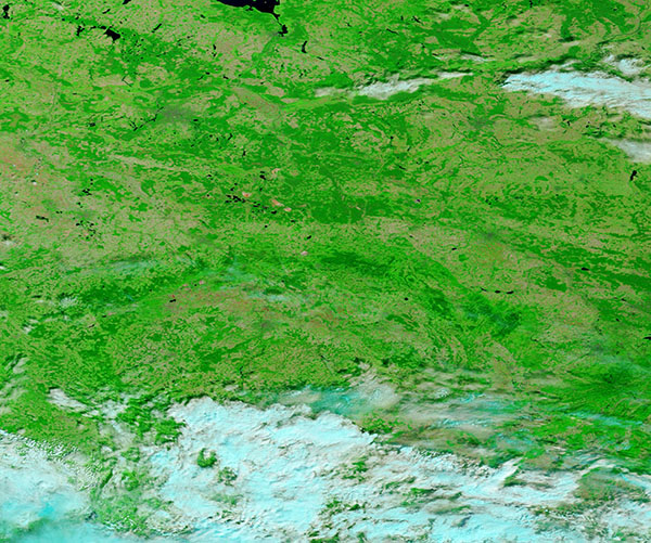
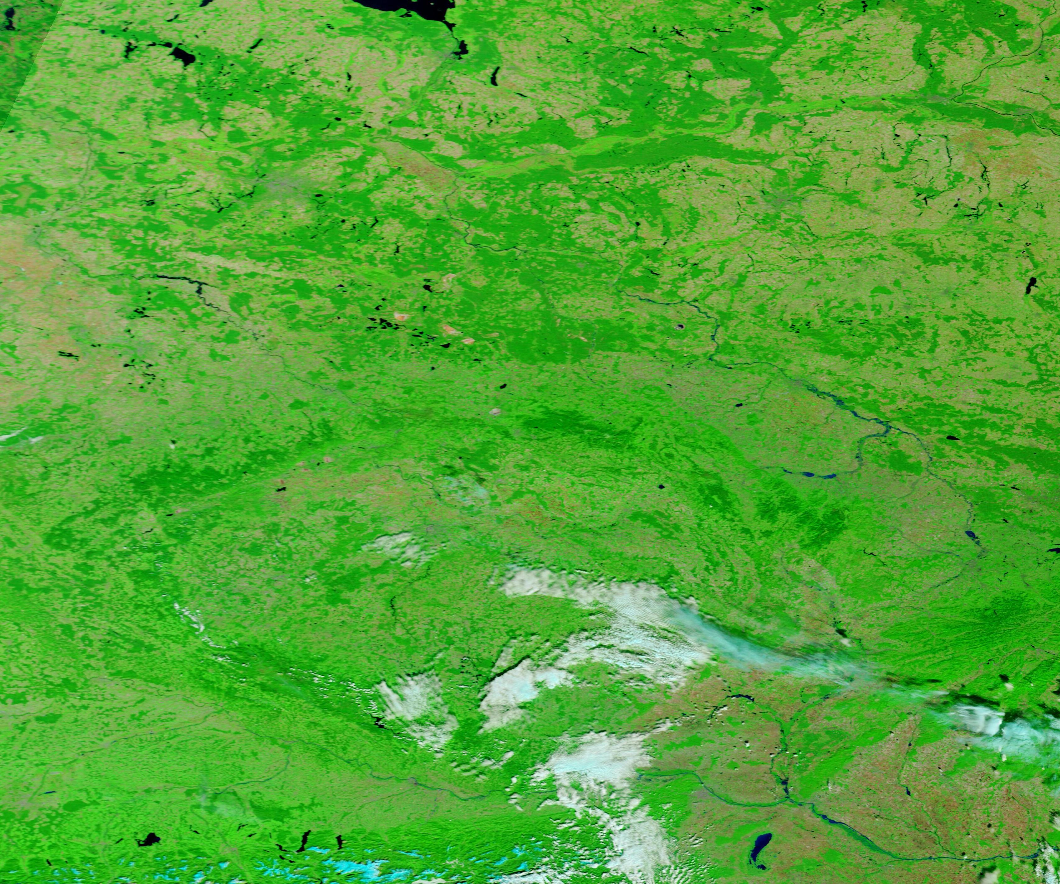
A drenching storm slammed Central and Eastern Europe in mid-September 2024, causing heaving flooding, the evacuation of thousands of people, and the death of at least 22 people. The first impacts of Storm Boris began on September 13, as rain and snow began to fall. According to the Center for Disaster Philanthropy, as much as a month’s worth of rain fell across many communities within 24 hours. The most severely affected countries included Austria, the Czech Republic, Croatia, Germany, Hungary, Italy, Poland, Romania, and Slovakia.
On September 20, when the Moderate Resolution Imaging Spectroradiometer (MODIS) on NASA’s Terra satellite acquired this false-color image of Central Europe, flooding was still evident in many places across the region. The extent of flooding may be better appreciated by comparison with a second false-color Terra MODIS image of the same area acquired on September 6, prior to the passage of Storm Boris. Each image can be viewed simply by clicking on the date.
This type of false-color image helps separate water, which appears dark blue, from vegetation, which looks bright green. In addition, open land shows as tan and clouds are often bright white but, if they are high, cold clouds containing ice crystals, may contain a light blue tint.
Several countries lie within the images, including Germany, Poland, The Czech Republic, Czechia, Austria, and Slovakia. On September 20, several rivers are notably enlarged and in flood stage. The most notable are the Danube, which flows near Vienna, Austria, is prominent in the south; the Oder River, which flows through Poland, can be seen in the east-central section of the image, while a portion of the River Elbe, in Germany, is visible in the north-central section. Neither the Elbe nor Oder can be seen on September 6, while the Danube is hidden under cloud in that earlier image.
Image Facts
Satellite:
Terra
Date Acquired: 9/20/2024
Resolutions:
1km (319.4 KB), 500m (736.3 KB), 250m (1.3 MB)
Bands Used: 1,4,3
Image Credit:
MODIS Land Rapid Response Team, NASA GSFC
September 20, 2024 September 6, 2024
A drenching storm slammed Central and Eastern Europe in mid-September 2024, causing heaving flooding, the evacuation of thousands of people, and the death of at least 22 people. The first impacts of Storm Boris began on September 13, as rain and snow began to fall. According to the Center for Disaster Philanthropy, as much as a month’s worth of rain fell across many communities within 24 hours. The most severely affected countries included Austria, the Czech Republic, Croatia, Germany, Hungary, Italy, Poland, Romania, and Slovakia.
On September 20, when the Moderate Resolution Imaging Spectroradiometer (MODIS) on NASA’s Terra satellite acquired this false-color image of Central Europe, flooding was still evident in many places across the region. The extent of flooding may be better appreciated by comparison with a second false-color Terra MODIS image of the same area acquired on September 6, prior to the passage of Storm Boris. Each image can be viewed simply by clicking on the date.
This type of false-color image helps separate water, which appears dark blue, from vegetation, which looks bright green. In addition, open land shows as tan and clouds are often bright white but, if they are high, cold clouds containing ice crystals, may contain a light blue tint.
Several countries lie within the images, including Germany, Poland, The Czech Republic, Czechia, Austria, and Slovakia. On September 20, several rivers are notably enlarged and in flood stage. The most notable are the Danube, which flows near Vienna, Austria, is prominent in the south; the Oder River, which flows through Poland, can be seen in the east-central section of the image, while a portion of the River Elbe, in Germany, is visible in the north-central section. Neither the Elbe nor Oder can be seen on September 6, while the Danube is hidden under cloud in that earlier image.
Image Facts
Satellite:
Terra
Date Acquired: 9/20/2024
Resolutions:
1km (319.4 KB), 500m (736.3 KB), 250m (1.3 MB)
Bands Used: 1,4,3
Image Credit:
MODIS Land Rapid Response Team, NASA GSFC
