
Images


August 28, 2017 - Hawaii
 Tweet
Tweet
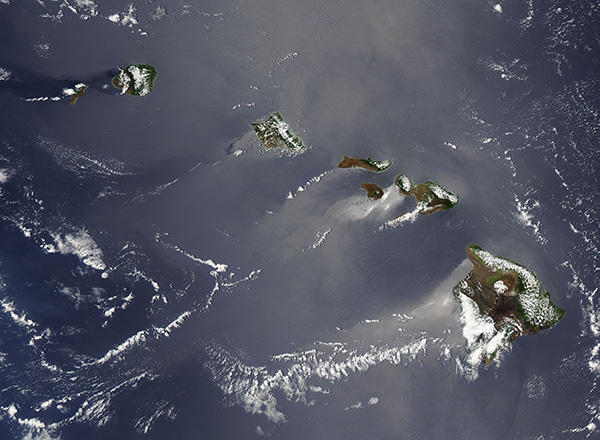
A combination of sunglint and cloud helped to create a stunning image of Hawaii in late July 2017. The Moderate Resolution Imaging Spectroradiometer (MODIS) aboard NASA’s Aqua satellite acquired this true-color image on July 27.
The beautiful Hawaiian Islands are made up of eight major islands stretching across almost 1,500 miles (2,400 km) in the Pacific Ocean. The rugged landscape of the islands was created by volcanic activity over millions of years, with the oldest island, Oahu, estimated to have been created between 3.4 to 2.2 million years ago. The process continues to this day, with two active volcanoes on Hawaii. Kilauea has been in continuous eruption since 1983 while Maunaloa last erupted in 1984. Loihi, an underwater volcano, has been intermittently pouring lava into the ocean since 1996 – a process that may ultimately result in the creation of a new island.
From the lower right (southeast) to the upper left (northwest), the islands visible in this image are the “Big Island” (Hawaii), Maui, Kahoolawe, Lanai, Molokai, Oahu, Kauai, and Niihau. Clouds cover much of each island, obscuring much of the green vegetation from view. The visible landscape appears mostly dark tan or black rocky outcroppings, where rainfall is lower and less vegetation grows.
Sunglint occurs when light is reflected from waters of the surface of the ocean back towards the sensor and it creates a silvery appearance in true-color images. Sunglint reveals turbulence in the surface of the water. If the surface was perfectly smooth, then – like a mirror – we could see the sun’s reflection as a large circle. Because the surface water is ruffled and roughened due to wave action, the reflection is scattered and softened, creating the silver-colored sunglint region.
In this image, the water surface around the Hawaiian Islands are roughened in varying patterns. Calmer water on the leeward side of the islands, are indicated by brighter silver color on the southwest side of most islands. In contrast, the cloud cover sits primarily on the windward side of the islands.
Image Facts
Satellite:
Aqua
Date Acquired: 7/26/2017
Resolutions:
1km (181.4 KB), 500m (466.4 KB), 250m (754.3 KB)
Bands Used: 1,4,3
Image Credit:
Jeff Schmaltz, MODIS Land Rapid Response Team, NASA GSFC
