
Images


December 23, 2017 - Tropical Storm Tembin (33W) over the Philippines
 Tweet
Tweet
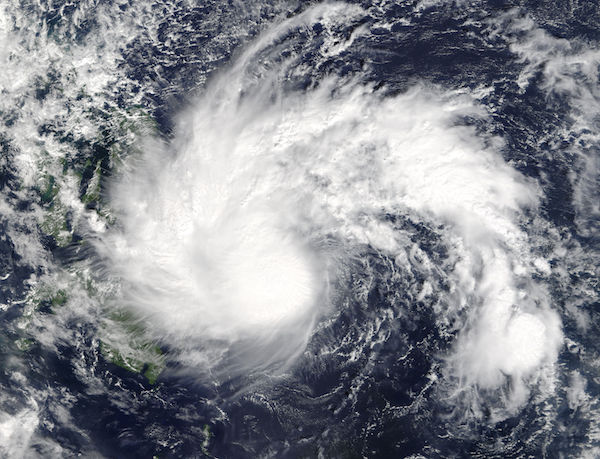
On December 21, 2017 NASA’s Terra satellite passed over the Northwestern Pacific Ocean, allowing the Moderate Resolution Imaging Spectroradiometer (MODIS) on board to acquire a true-color image of Tropical Storm Tembin (033) as it crossed the Philippines.
Tembin strengthened from a low-pressure area south of Elato on December 16 and then weakened back into a tropical depression. On December 20 the Joint Typhoon Warning Center (JTWC) issued a Tropical Cyclone Formation alert as the storm re-strengthened. The storm was named Tembin by JTWC and Vinta by the Philippine Atmospheric, Geophysical and Astronomical Services Administration (PAGASA).
At 10 a.m. EST (1500 UTC) on December 22, JTWC reported that Tembin had maximum sustained winds near 52 mph (83 km/h). It was located near 8.0 degrees north latitude and 121.5 degrees east longitude, about 401 nautical miles south of Manila, Philippines. It was exiting western Mindanao, the southern region of the country and moving toward the island of Palawan.
Also on December 22, PAGASA issued Public storm warning signal #1 for the Mindanao provinces of Lanao del Norte, Misamis Occidental, Zamboanga del Norte, Zamboanga del Sur, and Zamboanga Sibugay; the Visayas provinces of Southern Negros Oriental and Siquijor and the Luzon provinces of southern Palawan. Vinta made landfall in Cateel, Davao Oriental as a severe tropical storm on that same day. Seven people have been reported killed by the storm, and 4 others are missing.
JTWC expects Tembin to continue tracking westward into the South China Sea and make a second landfall near Ho Chi Minh City, Vietnam on Dec. 25.
Image Facts
Satellite:
Terra
Date Acquired: 12/21/2017
Resolutions:
1km (663.6 KB), 500m (2 MB), 250m (5 MB)
Bands Used: 1,4,3
Image Credit:
Jeff Schmaltz, MODIS Land Rapid Response Team, NASA GSFC
