
Images


July 13, 2019 - Tropical Storm Barry
 Tweet
Tweet
On July 10, 2019, the National Hurricane Center (NHC) issued the first warnings on potential tropical cyclone formation in the Gulf of Mexico, issuing a Tropical Storm Watch and a Storm Surge Watch from the mouth of the Mississippi River to Morgan City, Louisiana. A tropical storm watch means that tropical storm conditions are possible within the watch area, generally within 48 hours.
The disturbance strengthened to Tropical Storm Barry on July 11 as the center was located at 27.8 N and 88.7 W, or about 95 miles (150 km) south-southeast of the mouth of the Mississippi River and about 200 mi (320 km) southeast of Morgan City, Louisiana. Maximum sustained winds were 40 mph (65 km/h) at that time. The storm was moving slowly westward over the Gulf of Mexico. By the evening of July 11, a Hurricane Warning was issued for portions of the Louisiana Coast, with dangerous storm surge, heavy rains, and heavy wind conditions expected across the north-central Gulf coast as Barry continued to strengthen. In the last report of the day, the NHC estimated Tropical Storm Barry’s winds at 50 mph (85 km/h).
On July 12, Barry continued to crawl slowly to the north-northwest across the northern Gulf of Mexico as it continued to strengthen. Tropical Storm conditions began to affect the Louisiana coastline in the afternoon. At 5:00 p.m. EDT (2100 UTC), Barry was located about 70 miles (115 km) south-southeast of Morgan City Louisiana and about 110 mi (180 km) west-southwest of the mouth of the Mississippi River. Maximum sustained winds registered at 65 mph (100 km/h).
Barry is expected to make landfall in southern Louisiana on July 13 as a very strong tropical storm or Category 1 hurricane, with winds possibly as high as 75 mph (121 km/h). After landfall the storm will steadily weaken as it moves over central Louisiana and into Alabama, with a decay to a remnant low by July 16 and dissipation after July 17. Although wind speeds should stay relatively low for a hurricane, there is danger of life-threatening storm surge inundation along the coast of southern and southeastern Louisiana, portions of Lake Pontchartrain, and portions of coastal Mississippi. The highest storm surge inundation is expected between Intracoastal City and Shell Beach. The slow movement of the system will result in a long duration heavy rainfall and flood threat, including flash flooding and river flooding, some of which may be life-threatening. Local rainfall amounts may reach 25 inches (0.64 meters), according to national news media.
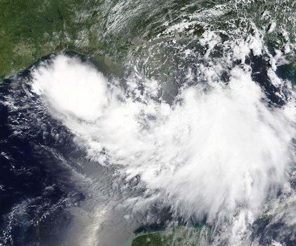
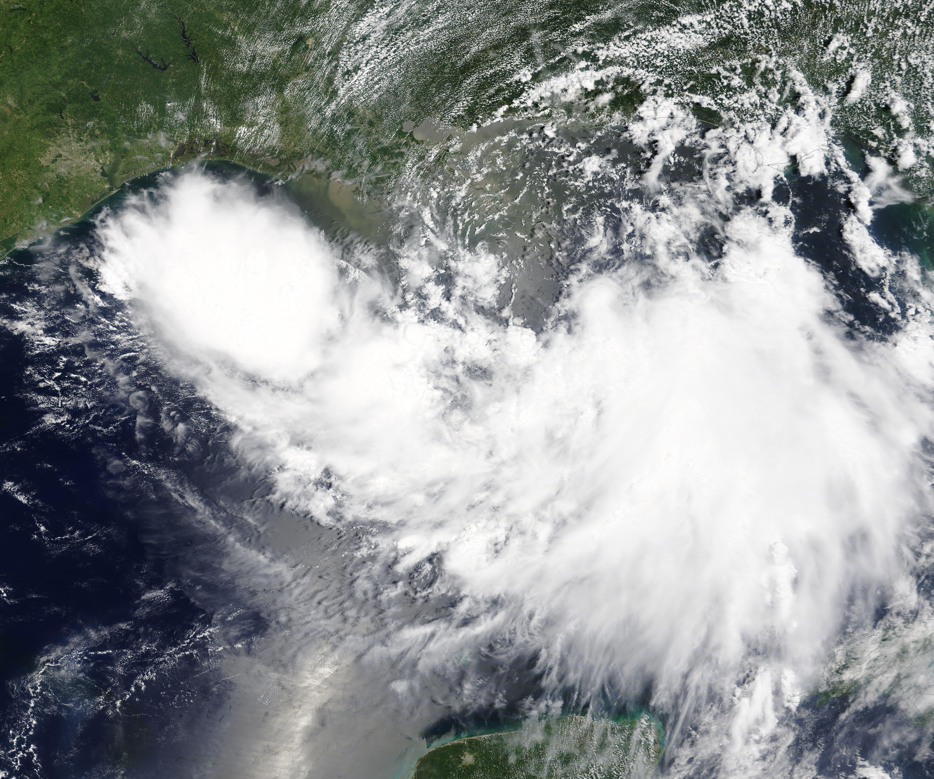
The Moderate Resolution Imaging Spectroradiometer (MODIS) on board NASA’s Terra satellite acquired a true-color image of Tropical Storm Barry approaching the Gulf Coast on July 11.
Image Facts
Satellite:
Terra
Date Acquired: 7/11/2019
Resolutions:
1km (1.4 MB), 500m (4.1 MB), 250m (3.7 MB)
Bands Used: 1,4,3
Image Credit:
MODIS Land Rapid Response Team, NASA GSFC
On July 10, 2019, the National Hurricane Center (NHC) issued the first warnings on potential tropical cyclone formation in the Gulf of Mexico, issuing a Tropical Storm Watch and a Storm Surge Watch from the mouth of the Mississippi River to Morgan City, Louisiana. A tropical storm watch means that tropical storm conditions are possible within the watch area, generally within 48 hours.
The disturbance strengthened to Tropical Storm Barry on July 11 as the center was located at 27.8 N and 88.7 W, or about 95 miles (150 km) south-southeast of the mouth of the Mississippi River and about 200 mi (320 km) southeast of Morgan City, Louisiana. Maximum sustained winds were 40 mph (65 km/h) at that time. The storm was moving slowly westward over the Gulf of Mexico. By the evening of July 11, a Hurricane Warning was issued for portions of the Louisiana Coast, with dangerous storm surge, heavy rains, and heavy wind conditions expected across the north-central Gulf coast as Barry continued to strengthen. In the last report of the day, the NHC estimated Tropical Storm Barry’s winds at 50 mph (85 km/h).
On July 12, Barry continued to crawl slowly to the north-northwest across the northern Gulf of Mexico as it continued to strengthen. Tropical Storm conditions began to affect the Louisiana coastline in the afternoon. At 5:00 p.m. EDT (2100 UTC), Barry was located about 70 miles (115 km) south-southeast of Morgan City Louisiana and about 110 mi (180 km) west-southwest of the mouth of the Mississippi River. Maximum sustained winds registered at 65 mph (100 km/h).
Barry is expected to make landfall in southern Louisiana on July 13 as a very strong tropical storm or Category 1 hurricane, with winds possibly as high as 75 mph (121 km/h). After landfall the storm will steadily weaken as it moves over central Louisiana and into Alabama, with a decay to a remnant low by July 16 and dissipation after July 17. Although wind speeds should stay relatively low for a hurricane, there is danger of life-threatening storm surge inundation along the coast of southern and southeastern Louisiana, portions of Lake Pontchartrain, and portions of coastal Mississippi. The highest storm surge inundation is expected between Intracoastal City and Shell Beach. The slow movement of the system will result in a long duration heavy rainfall and flood threat, including flash flooding and river flooding, some of which may be life-threatening. Local rainfall amounts may reach 25 inches (0.64 meters), according to national news media.
The Moderate Resolution Imaging Spectroradiometer (MODIS) on board NASA’s Terra satellite acquired a true-color image of Tropical Storm Barry approaching the Gulf Coast on July 11.
Image Facts
Satellite:
Terra
Date Acquired: 7/11/2019
Resolutions:
1km (1.4 MB), 500m (4.1 MB), 250m (3.7 MB)
Bands Used: 1,4,3
Image Credit:
MODIS Land Rapid Response Team, NASA GSFC
