
Images


September 7, 2019 - Hurricane Dorian
 Tweet
Tweet
After brutally battering the Bahamas, Hurricane Dorian made a rapid dash along the East Coast of the United States, making landfall on the Outer Banks of North Carolina around 6 a.m. EDT on September 6, 2019 before speeding off towards Nova Scotia, Canada. At the time the eyewall of Dorian was moving across the Outer Banks, the National Hurricane Center (NHC) reported that the storm was carrying maximum sustained winds of 90 mph (150 km/h), making it a Category 1 hurricane on the Saffir Simpson Wind Scale. The storm was a devastating Category 5 storm as it lingered over the Bahamas from September 1 through September 3, packing maximum sustained winds of 185 mph (295 km/h) with higher gusts.
Flooding on the Outer Banks has been reported at “catastrophic”, leaving about 800 people stranded as of September 6. In addition, nearly 350,000 residents and businesses in North and South Carolina were left without power, according to CBS News. Damage on the Bahamas was even more extensive, with over 76,200 people affected. Global Disaster Alert and Coordination System (GDACS) reported that 60 percent of the homes on northern Abaco were destroyed or severely damaged. Prime Minister Hubert Minnis was quoted as saying the storm inflicted “general devastation”. As of September 6, the death toll in the Bahamas sits at 43, but officials are warning that hundreds, possibly thousands, remain missing and that the death toll is expected to rise substantially.
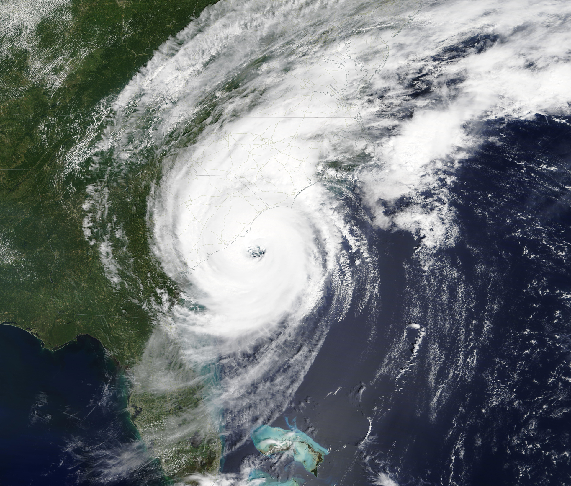
The Moderate Resolution Imaging Spectroradiometer (MODIS) on board NASA’s Aqua satellite acquired a true-color image of Hurricane Dorian traveling up the Southeastern United States on September 5. Thick bands of clouds were circulating a large, nearly cloud-free eye which was located off the southern coast of South Carolina. Hurricane eyes average about 20 miles (32 km) in diameter; the NHC reported that Dorian’s eye reached a diameter of 50 miles (80 km) on September 5. Rain-bearing clouds extended well inland across Georgia, South Carolina, and North Carolina.
Image Facts
Satellite:
Aqua
Date Acquired: 9/5/2019
Resolutions:
1km (2.2 MB), 500m (6.5 MB), 250m (5.3 MB)
Bands Used: 1,4,3
Image Credit:
MODIS Land Rapid Response Team, NASA GSFC
After brutally battering the Bahamas, Hurricane Dorian made a rapid dash along the East Coast of the United States, making landfall on the Outer Banks of North Carolina around 6 a.m. EDT on September 6, 2019 before speeding off towards Nova Scotia, Canada. At the time the eyewall of Dorian was moving across the Outer Banks, the National Hurricane Center (NHC) reported that the storm was carrying maximum sustained winds of 90 mph (150 km/h), making it a Category 1 hurricane on the Saffir Simpson Wind Scale. The storm was a devastating Category 5 storm as it lingered over the Bahamas from September 1 through September 3, packing maximum sustained winds of 185 mph (295 km/h) with higher gusts.
Flooding on the Outer Banks has been reported at “catastrophic”, leaving about 800 people stranded as of September 6. In addition, nearly 350,000 residents and businesses in North and South Carolina were left without power, according to CBS News. Damage on the Bahamas was even more extensive, with over 76,200 people affected. Global Disaster Alert and Coordination System (GDACS) reported that 60 percent of the homes on northern Abaco were destroyed or severely damaged. Prime Minister Hubert Minnis was quoted as saying the storm inflicted “general devastation”. As of September 6, the death toll in the Bahamas sits at 43, but officials are warning that hundreds, possibly thousands, remain missing and that the death toll is expected to rise substantially.
The Moderate Resolution Imaging Spectroradiometer (MODIS) on board NASA’s Aqua satellite acquired a true-color image of Hurricane Dorian traveling up the Southeastern United States on September 5. Thick bands of clouds were circulating a large, nearly cloud-free eye which was located off the southern coast of South Carolina. Hurricane eyes average about 20 miles (32 km) in diameter; the NHC reported that Dorian’s eye reached a diameter of 50 miles (80 km) on September 5. Rain-bearing clouds extended well inland across Georgia, South Carolina, and North Carolina.
Image Facts
Satellite:
Aqua
Date Acquired: 9/5/2019
Resolutions:
1km (2.2 MB), 500m (6.5 MB), 250m (5.3 MB)
Bands Used: 1,4,3
Image Credit:
MODIS Land Rapid Response Team, NASA GSFC
