Images
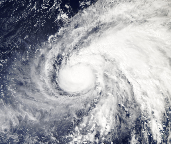
November 5, 2019 - Typhoon Halong
Tweet
Typhoon Halong continued to strengthen over the Northwest Pacific Ocean when NASA’s Aqua satellite passed overhead on November 4, 2019. The Moderate Resolution Imaging Spectroradiometer (MODIS) on board that satellite acquired a true-color image of the storm the same day.
Halong developed on November 2 from a low-pressure area designated as System 99W. The storm consolidated into a tropical storm later that day. On November 3, Halong intensified further and became a typhoon.
On November 4 at 4 p.m. EST (2100 UTC), the Joint Typhoon Warning Center (JTWC) reported that Typhoon Halong had maximum sustained winds near 121 mph (195 km/h) or a Category 3 storm on the Saffir-Simpson Hurricane Wind Scale. At that time, Halong had developed an eye as it intensified, and was located about 493 mi (793 km) east-northeast of Saipan. It was tracking northwestward at about 7 mph (11 km/h).
According to the JTWC, analysis indicated a favorable environment with low wind shear. This should allow Typhoon Halong to strengthen to a peak maximum wind speed of about 144 mph (232 km/h) by the evening of November 5. After that time, it is expected to turn northward, then to the northeast as it begins to weaken over open ocean. Fortunately, Halong is not expected to interact with land.
Image Facts
Satellite:
Aqua
Date Acquired: 11/4/2019
Resolutions:
1km (1.9 MB), 500m (5.5 MB), 250m (9.6 MB)
Bands Used: 1,4,3
Image Credit:
MODIS Land Rapid Response Team, NASA GSFC
Tweet
Typhoon Halong continued to strengthen over the Northwest Pacific Ocean when NASA’s Aqua satellite passed overhead on November 4, 2019. The Moderate Resolution Imaging Spectroradiometer (MODIS) on board that satellite acquired a true-color image of the storm the same day.
Halong developed on November 2 from a low-pressure area designated as System 99W. The storm consolidated into a tropical storm later that day. On November 3, Halong intensified further and became a typhoon. On November 4 at 4 p.m. EST (2100 UTC), the Joint Typhoon Warning Center (JTWC) reported that Typhoon Halong had maximum sustained winds near 121 mph (195 km/h) or a Category 3 storm on the Saffir-Simpson Hurricane Wind Scale. At that time, Halong had developed an eye as it intensified, and was located about 493 mi (793 km) east-northeast of Saipan. It was tracking northwestward at about 7 mph (11 km/h).
According to the JTWC, analysis indicated a favorable environment with low wind shear. This should allow Typhoon Halong to strengthen to a peak maximum wind speed of about 144 mph (232 km/h) by the evening of November 5. After that time, it is expected to turn northward, then to the northeast as it begins to weaken over open ocean. Fortunately, Halong is not expected to interact with land.
Image Facts
Satellite:
Aqua
Date Acquired: 11/4/2019
Resolutions:
1km (1.9 MB), 500m (5.5 MB), 250m (9.6 MB)
Bands Used: 1,4,3
Image Credit:
MODIS Land Rapid Response Team, NASA GSFC


