
Images


November 30, 2019 - Typhoon Kammuri
 Tweet
Tweet
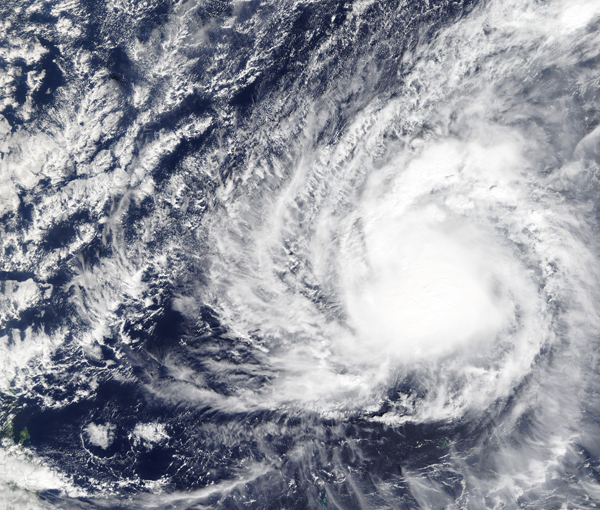
On November 29, 2019, the Moderate Resolution Imaging Spectroradiometer (MODIS) on board NASA’s Terra satellite acquired a true-color image of Typhoon Kammuri as it strengthened over the Pacific Ocean on its way to a potential landfall with the Philippines. The storm first rose from a low pressure system that formed southeast of Guam on November 23, strengthening to a severe tropical storm on November 27 after it passed south of Guam.
On November 29, at 7:00 p.m. CHST, local time, Guam (4:00 a.m. EST/0900 UTC), the National Weather Service in Tiyan, Guam, noted that the center of typhoon Kammuri was located near latitude 14.5 degrees north and longitude 137.3 degrees east. That puts the eye of Kammuri about 350 miles (563 km) north-northwest of Ulithi, 350 miles (563 km) north of Yap, 395 miles (636 km) north-northwest of Fais and 505 miles (813 km) west of Guam.
Kammuri is moving west-northwest at 7 mph (11 km/h). It is expected to make a turn toward the west-southwest with a slight increase in forward speed over the next 24 hours. Maximum sustained winds have increased to 85 mph (137 km/h). Kammuri is forecast to maintain this intensity through Saturday, November 30 and strengthen again after that time. Typhoon force winds extend outward from the center up to 35 miles (56 km). Tropical storm force winds extend outward from the Center up to 145 miles (233 km).
The forecast track for Kammuri takes the storm due west toward the Philippines. The forecast from Joint Typhoon Warning Center has Kammuri intensifying to about 125 knots (144 mph/232 km/h) by December 1, 2019, which would be the equivalent to a strong Category 4 storm on the Saffir-Simpson Hurricane Wind Scale. The storm is expected to make landfall in the central and northern Philippines on December 3.
Image Facts
Satellite:
Terra
Date Acquired: 11/29/2019
Resolutions:
1km (2.5 MB), 500m (7.2 MB), 250m (5.9 MB)
Bands Used: 1,4,3
Image Credit:
MODIS Land Rapid Response Team, NASA GSFC
